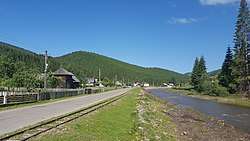
Moldovița (river)
The Moldovița (in its upper course also: Roșoșa) is a left tributary of the river Moldova in Romania.[1][2][3] It discharges into the Moldova in Vama. It flows through the villages Argel, Rașca, Moldovița, Vatra Moldoviței, Frumosu, Strâmtura and Vama. Its length is 48 km (30 mi) and its basin size is 549 km2 (212 sq mi).[2]
| Moldovița | |
|---|---|
 The Moldovița passing through Argel | |
| Location | |
| Country | Romania |
| Counties | Suceava County |
| Physical characteristics | |
| Mouth | Moldova |
• location | Vama |
• coordinates | 47.5696°N 25.7049°E |
| Length | 48 km (30 mi) |
| Basin size | 549 km2 (212 sq mi) |
| Basin features | |
| Progression | Moldova→ Siret→ Danube→ Black Sea |
Tributaries
The following rivers are tributaries to the river Moldovița:[2]
- Left: Dubu, Rașcova (Rașca), Săcrieș, Ciumârna, Lupoaia, Dragoșa, Frumosul
- Right: Argel, Lunguleț, Demăcușa, Vulcan, Pârâul Boului, Deia
gollark: And it just has such weird inconsistency. Also bad async handling.
gollark: Also the ecosystem gets deprecated every month or so.
gollark: MC is just awfully designed.
gollark: Strange implicit conversions.
gollark: Easy to pick up maybe, but the ecosystem is a *mess* and the type system is essentially nonexistent.
References
- "Planul național de management. Sinteza planurilor de management la nivel de bazine/spații hidrografice, anexa 7.1" (PDF, 5.1 MB). Administrația Națională Apele Române. 2010. p. 933.
- Atlasul cadastrului apelor din România. Partea 1 (in Romanian). Bucharest: Ministerul Mediului. 1992. pp. 377–378. OCLC 895459847. River code: XII.1.40.20
- Ovidiu Gabor - "Economic Mechanism in Water Management" (PDF). Archived from the original (PDF) on 5 March 2009., map page 10
- Trasee turistice - Județul Suceava
- Mołdawica in the Geographical Dictionary of the Kingdom of Poland, volume VI (Malczyce — Netreba) 1885, S. 644. (in Polish)
This article is issued from Wikipedia. The text is licensed under Creative Commons - Attribution - Sharealike. Additional terms may apply for the media files.