Mkinga District
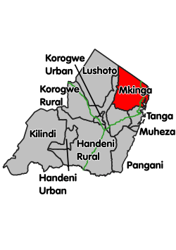
Mkinga District is one of the ten districts of Tanga Region in Tanzania. It split from Muheza District in 2007. The administrative capital of the district is located in a village called Kasera.[1]
Mkinga District Wilaya ya Mkinga (Swahili) | |
|---|---|
 Location within Tanga Region (red) | |
| Country | Tanzania |
| Zone | Northern |
| Region | Tanga |
| Incorporated District | 1 July 2007 |
| Government | |
| • District Commissioner | Deodatus Kinawiro |
| Area | |
| • Total | 2,711.93 km2 (1,047.08 sq mi) |
| Population (2012) | |
| • Total | 118,065 |
| • Density | 44/km2 (110/sq mi) |
| Time zone | UTC+3 (EAT) |
| Postcode | 215xx |
| Area code(s) | 027 |
| Website | www |
According to the 2012 Tanzania National Census, the population of Mkinga District was 118,065.[2]
Administrative subdivisions
Wards
As of 2012, Mkinga District is administratively divided into 21 wards:[2]
- Boma
- Bosha
- Bwiti
- Daluni
- Doda
- Duga
- Gombero
- Kigongoi
- Kwale
- Manza
- Mapatano
- Maramba
- Mayomboni
- Mhinduro
- Mkinga
- Mnyenzani
- Moa
- Mtimbwani
- Mwakijembe
- Parungu Kasera
- Sigaya
Transport
Paved trunk road T13 from Tanga to the Kenyan border passes through the district.[3]
gollark: I have t5-small-ssm-nq determine whether all messages on esolangs are code-guessing-related or not, and archive the code-guessing ones to the osmarks.net backup system.
gollark: This person was interviewing for GTech™ without even knowing what potatOS contains!
gollark: They really don't understand apiodynamic theory.
gollark: This is further evidence of wrong.
gollark: I gave them 10 trolley problems and had them pick their favourite one and response to it.
References
- "Main Page". Mkinga District Council. Retrieved 8 August 2019.
- "2012 Population and Housing Census" (PDF). Development Partners Group Tanzania. Retrieved 7 August 2019.
- "Tanga Region Roads Network" (PDF). Tanroads. Retrieved 8 August 2019.
This article is issued from Wikipedia. The text is licensed under Creative Commons - Attribution - Sharealike. Additional terms may apply for the media files.