Mizda District
Mizda was one of the districts of Libya. In the 2007 reorganization of Libyan districts its territory became part of Jabal al Gharbi District.[1]
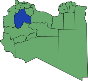
Prior to 2007 Mizdah bordered the following districts:
- Bani Walid - northeast
- Sirte - east
- Al Jufrah - southeast
- Wadi Al Shatii - south
- Ghadames - west
- Nalut - northwest, south of Yafran
- Yafran - northwest, north of Nalut
- Gharyan - north
- Tarhuna wa Msalata - northeast, at a quadripoint
At the time Mizda bordered more districts than any other Libyan district.
Settlements
The following are important settlements in the former Mizda District:[2]
- Mizda (مزدة) a town at 31° 25' 20"N 12° 57' 0"E
- Nasmah (-نسمة) a village at 31° 23' 0 N 13° 17' 0 E
- Bi'r Abu al Ghurab or Abu West (أبو الغرب) a village at 30° 38' 0 N 13° 36' 0 E
- Al Qaryah al Gharbīyah (القرية الغربية) at 30° 24' 24" N 13° 25' 14" E
- Tabaqa (طبقة) at 30° 25' 53" N 13° 19' 7" E [3]
- Ash Shuwayrif or Esc Sciuere (الشويرف) at 29° 59' 20" N 14° 15' 20" E[4]
- Fessano or Fisānū (فسانو) also Fessano Almchachep (منطقة فسانو) or Sawani Fassanu at 31° 18' 19" N 12° 47' 42" E
- Qaryat (القرية الشرقية) at 30° 23' 17" N 13° 34' 50" E
- Ash Shaqiqa (الشقيقة) a village at 31° 38' 22" N 12° 48' 24" E
Notes
- شعبيات الجماهيرية العظمى – Sha'biyat of Great Jamahiriya Archived 2009-02-07 at the Wayback Machine, accessed 21 June 2009, in Arabic
- Districts of Libya:Mizdah Website of the General People's Committee of Libya, in Arabic, from Internet Archive dated 30 August 2006
- photo of Tabaqah Panoramio
- photo of Ash Shuwayrif Panoramio
gollark: <@689526211659169856> s
gollark: Oh, how about just Unioc?
gollark: Unixoc.
gollark: Oh right, Protocol Epsilon is just *logging*, time to launch... Protocol Zeta?
gollark: You are now an alcoholic.
This article is issued from Wikipedia. The text is licensed under Creative Commons - Attribution - Sharealike. Additional terms may apply for the media files.