Mitooma
Mitooma is a town in the Western Region of Uganda. It is the main municipal, administrative, and commercial center of Mitooma District.
Mitooma | |
|---|---|
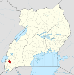
 Mitooma Location in Uganda | |
| Coordinates: 00°36′54″S 30°02′42″E | |
| Country | |
| Region | Western Region of Uganda |
| Sub-region | Ankole sub-region |
| District | Mitooma District |
| Elevation | 5,600 ft (1,700 m) |
| Population (2013 Est.) | |
| • Total | 22,000 |
Location
Mitooma is approximately 24 kilometres (15 mi), by road, southwest of Bushenyi, the nearest large town.[1] This is approximately 85 kilometres (53 mi), by road, west of Mbarara, the largest city in the Ankole sub-region.[2] The coordinates of the town are 0°36'54.0"S, 30°02'42.0"E (Latitude:-0.6150; Longitude:30.0450).[3]
Population
In November 2013, the population of Mitooma Municipality was estimated at 22,000.[4]
Points of interest
- headquarters of Mitooma District Administration
- offices of Mitooma Town Council
- Ishaka-Rukungiri road, a heavily pot-holed 50 kilometres (31 mi) dirt road, going through the middle of town
- Mitooma central market
gollark: Surely your improvements should *reduce* hardware requirements?
gollark: Remind me to not live there.
gollark: *Specifically* the jungle?
gollark: If dynmap is working this will look... interesting on that.
gollark: Funlolz? Stress testing?
References
- "Road Distance Between Bushenyi And Mitooma With Map". Globefeed.com. Retrieved 8 June 2014.
- "Approximate Road Distance Between Mbarara And Mitooma With Map". Globefeed.com. Retrieved 8 June 2014.
- Google (18 July 2015). "Location of Mitooma at Google Maps" (Map). Google Maps. Google. Retrieved 18 July 2015.
- Vision, Reporter (17 November 2013). "Mitooma uses one latrine". New Vision. Retrieved 26 July 2015.
External links
This article is issued from Wikipedia. The text is licensed under Creative Commons - Attribution - Sharealike. Additional terms may apply for the media files.