Minnesota State Highway 60
Trunk Highway 60 (MN 60) is a 221.532-mile-long (356.521 km) highway in southern Minnesota, which runs from Iowa Highway 60 at the Iowa state line (at Bigelow) and continues east-northeast to its eastern terminus at the Wisconsin state line (at Wabasha), where the route becomes Wisconsin Highway 25 upon crossing the Mississippi River.
| ||||
|---|---|---|---|---|
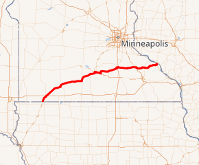
MN 60 highlighted in red | ||||
| Route information | ||||
| Maintained by MnDOT | ||||
| Length | 221.532 mi[1] (356.521 km) | |||
| Existed | 1934[2]–present | |||
| Major junctions | ||||
| West end | ||||
| ||||
| East end | ||||
| Location | ||||
| Counties | Nobles, Jackson, Cottonwood, Watonwan, Blue Earth, Nicollet, Le Sueur, Waseca, Rice, Goodhue, Wabasha | |||
| Highway system | ||||
| ||||

Highway 60 is the only state highway in Minnesota which runs from one border to another. The route runs in a general southwest-to-northeast direction.
Its western half forms a large portion of the four-lane expressway connecting Sioux City and the Twin Cities.
Route description
State Highway 60 serves as an east–west marked route in southern Minnesota between Worthington, Windom, St. James, Mankato, Faribault, Zumbrota, and Wabasha.
Highway 60 runs concurrently with U.S. Highway 59 south of and into Worthington; with U.S. Highway 71 in Windom; with State Highway 4 and State Highway 30 near St. James; with State Highway 15 near Madelia; and with U.S. Highway 169 in the Mankato area.
In North Mankato, Highway 60 moves from a concurrency with U.S. 169 to another one with U.S. Highway 14, continuing east on a four lane expressway until just past Eagle Lake, where the route leaves U.S. 14 and continues briefly north to Madison Lake then northeast towards the city of Faribault. Highway 60 is a two lane highway at this point and for most of the rest of its way to Faribault and Wabasha. The route has a junction with Interstate 35 in Faribault.
From Faribault, Highway 60 continues east towards Zumbrota, where it intersects U.S. Highway 52. The route briefly runs concurrently with U.S. 52 around Zumbrota on a four lane expressway. Highway 60 then leaves U.S. 52 and continues east-northeast towards Wabasha. The route has junction with U.S. Highway 63 in Zumbro Falls and a junction with U.S. Highway 61 in Wabasha. Highway 60 crosses the Mississippi River at Wabasha on the Wabasha-Nelson Bridge. The route becomes Wisconsin Highway 25 upon crossing the river into Wisconsin.
History
State Highway 60 was formed in 1934 by connecting three Minnesota constitutional route segments together. This formed a nearly border-to-border state highway, with its original termini at current U.S. 59 in Worthington and U.S. 61 at Wabasha. The route was extended to the Iowa state line in 1937, and was authorized onto the bridge to Wisconsin in 1943. The last gravel segment on this route was paved by 1960. Expressway segments were completed from St. James to Lake Crystal in 1980, from Worthington to Windom in 1997, from Bigelow to Worthington in 2013, from St. James to Mountain Lake in 2015, and from Mountain Lake to Windom in 2018.
Major intersections
| County | Location | mi[1] | km | Destinations | Notes |
|---|---|---|---|---|---|
| Nobles | Bigelow Township | 0.000 | 0.000 | Iowa state line; road continues south as Iowa 60 | |
| 4.659 | 7.498 | Western end of US 59 overlap | |||
| Worthington | 11.249 | 18.104 | Roundabout; eastern end of US 59 overlap; western end of business loop 90 overlap | ||
| 12.097– 12.120 | 19.468– 19.505 | Interchange; I-90 exit 45; eastern end of business loop 90 | |||
| Jackson | Delafield Township | 36.290 | 58.403 | ||
| Cottonwood | Windom | 40.022 | 64.409 | Western end of US 71 overlap | |
| 40.554 | 65.265 | ||||
| 41.505 | 66.796 | Eastern end of US 71 overlap | |||
| Watonwan | St. James Township | 65.594 | 105.563 | Western end of expressway section; western end of MN 4 overlap | |
| St. James | 68.105 | 109.604 | Eastern end of MN 4 overlap, western end of MN 30 overlap | ||
| Rosendale Township | 69.844 | 112.403 | Eastern end of expressway section | ||
| Fieldon Township | 77.789 | 125.189 | Interchange; eastern end of MN 30 overlap, western end of MN 15 overlap | ||
| Madelia | 81.780– 81.826 | 131.612– 131.686 | Western end of expressway section | ||
| 83.043 | 133.645 | ||||
| 83.468 | 134.329 | Eastern end of expressway section; eastern end of MN 15 overlap | |||
| Blue Earth | Garden City | 93.667 | 150.742 | Partial interchange; westbound exit and entrance; eastbound access via 510th Avenue | |
| South Bend Township | 99.183 | 159.620 | Western end of US 169 overlap | ||
| 100.863– 100.921 | 162.323– 162.417 | Partial interchange; entrances and eastbound exit; westbound exit via at-grade left turn | |||
| 102.095 | 164.306 | ||||
| Mankato | 103.494 | 166.557 | Frontage Road | Western end of expressway section; eastbound exit and westbound entrance | |
| 104.378 | 167.980 | Riverfront Drive | Former MN 66 | ||
| Nicollet | North Mankato | 104.356 | 167.945 | Lookout Drive / Center Street | Center Street not signed westbound |
| 105.005 | 168.989 | North Mankato, Mankato, Downtown | Eastern end of expressway section | ||
| North Mankato–Mankato line | 107.096 | 172.354 | Interchange; western end of freeway section; eastern end of US 169 overlap, western end of US 14 overlap | ||
| Blue Earth | Mankato | 108.228 | 174.176 | ||
| 108.836 | 175.155 | Riverfront Drive | |||
| 109.881– 109.913 | 176.836– 176.888 | ||||
| 110.846 | 178.389 | ||||
| 113.713 | 183.003 | Eastern end of freeway section | |||
| Le Ray Township | 117.454 | 189.024 | Eastern end of US 14 overlap | ||
| Le Sueur | Waterville | 134.590 | 216.602 | ||
| Rice | Faribault | 148.856 | 239.561 | Parclo interchange; I-35 exit 56 | |
| 149.828 | 241.125 | ||||
| 151.659 | 244.072 | ||||
| Goodhue | Kenyon | 165.464 | 266.288 | Western end of MN 56 overlap | |
| 166.018 | 267.180 | Eastern end of MN 56 overlap | |||
| Wanamingo | 175.922 | 283.119 | |||
| Zumbrota | 181.266 | 291.719 | Interchange; western end of freeway section; western end of US 52 overlap | ||
| 182.655 | 293.955 | ||||
| 183.703 | 295.641 | Interchange; eastern end of freeway section; eastern end of US 52 overlap | |||
| Wabasha | Zumbro Falls | 196.051 | 315.514 | ||
| Wabasha | 220.051 | 354.138 | |||
| Mississippi River | 221.532 | 356.521 | Michael Duane Clickner Memorial Bridge | ||
| Continuation into Wisconsin | |||||
1.000 mi = 1.609 km; 1.000 km = 0.621 mi
| |||||
References
- Minnesota Department of Transportation (May 10, 2016). "Statewide Trunk Logpoint Listing" (PDF). St. Paul: Minnesota Department of Transportation. Retrieved March 24, 2017.
- Riner, Steve. "Details of Routes 51-75". The Unofficial Minnesota Highways Page. Retrieved 2006-12-16.