Iowa Highway 60
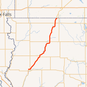
Iowa Highway 60 (Iowa 60) is a north–south state highway in northwest Iowa. The highway runs at a southwest-to-northeast angle. The southern end of Iowa Highway 60 is near Le Mars at a freeway interchange with U.S. Route 75 and U.S. Route 75 Business. Its northern end is at the Minnesota border just south of Bigelow, Minnesota, where the highway continues in Minnesota as Minnesota State Highway 60.
| |||||||
|---|---|---|---|---|---|---|---|

Iowa 60 highlighted in red | |||||||
| Route information | |||||||
| Maintained by Iowa DOT | |||||||
| Length | 58.771 mi[1] (94.583 km) | ||||||
| Existed | January 1, 1969–present | ||||||
| Major junctions | |||||||
| South end | |||||||
| North end | |||||||
| Location | |||||||
| Counties | |||||||
| Highway system | |||||||
| |||||||
The highway was designated on January 1, 1969, when it replaced Iowa 33. It was renumbered to provide a continuous number across the state line into Minnesota. Since 2004, the highway has been upgraded to expressway status, with some freeway sections, as part of a highway corridor connecting Sioux City with the Twin Cities metropolitan area in Minnesota.
Route description
Iowa 60 begins north of Le Mars at an interchange with U.S. Route 75 (US 75) and its business loop. Northbound Iowa 60 is a continuation of northbound US 75, while northbound US 75 traffic must exit to continue on that route. Iowa 60 heads to the northeast adjacent to the Floyd River along a four-lane expressway. Over its first 13 miles (21 km), it passes the small town of Seney and acres (hectares) of farmland until it reaches Alton.[2]
It continues northeast, bypassing Hospers and Sheldon. On the Sheldon bypass, it meets U.S. Highway 18. It proceeds north and bypasses Ashton, then continues northeast to bypass Sibley, where it meets Iowa Highway 9. The highway continues northeasterly until ending at the Minnesota border just south of Bigelow, Minnesota.
Exit list
| County | Location | mi[1] | km | Exit[2] | Destinations | Notes |
|---|---|---|---|---|---|---|
| Plymouth | America Township | 0.000 | 0.000 | 120 | Freeway continuation past interchange; exit number is based on US 75 exit numbering | |
| Sioux | Nassau Township | 13.317 | 21.432 | 12 | Alton | |
| Alton | 16.201 | 26.073 | 16 | Access via unsigned Iowa 450 (450th Street); serves Orange City Area Hospital | ||
| Sioux–O'Brien county line | Lynn–Carroll township line | 30.754 | 49.494 | 31 | ||
| O'Brien | Carroll Township | 32.817 | 52.814 | 33 | Country Club Road | |
| Sheldon | 34.433 | 55.415 | 34 | |||
| Osceola | West Holman Township | 48.861 | 78.634 | 48 | 2nd Avenue | |
| East Holman Township | 51.588 | 83.023 | 51 | Access to Osceola Community Hospital | ||
| East Holman–Wilson township line | 53.576 | 86.222 | 53 | |||
| Wilson Township | 58.771 | 94.583 | Continuation east into Minnesota as MN 60 | |||
| 1.000 mi = 1.609 km; 1.000 km = 0.621 mi | ||||||
Related route
| |
|---|---|
| Location | Sheldon |
Iowa Highway 60 Business serves Sheldon, following the old route of Iowa 60 north into Sheldon, then turning east on U.S. 18 to return to Iowa 60.
References
- 2009 Volume of Traffic on the Primary Road System of Iowa (PDF) (Report). Iowa Department of Transportation. January 1, 2009. Retrieved September 13, 2010.
- Iowa Department of Transportation (2010). State of Iowa Transportation Map (PDF) (Map). Ames: Iowa Department of Transportation. Retrieved September 13, 2010.
External links
- End of Iowa 60 at Iowa Highway Ends
