Mill Hollow
Mill Hollow is a valley in northern Douglas County the Ozarks of southern Missouri.[1]

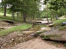
Roadside park in Mill Hollow adjacent to Missouri Route 5
The headwaters of the stream that occupies the hollow are at 37°01′28″N 92°38′26″W and the confluence with Bryant Creek is at 37°02′06″N 92°36′33″W.[1] The stream in the valley is fed by a perennial spring with its source near the upper reaches of the valley. Missouri Route 5 runs parallel to the valley on the southeast side.[2][3] The valley is the location of Ava Roadside Park which lies adjacent to Route 5 five miles north of Ava.
Mill Hollow was named for a mill which once stood in the valley in the 1830s.[4]
References
- U.S. Geological Survey Geographic Names Information System: Mill Hollow
- Cedar Gap, Missouri 7.5 Minute Topographic Quadrangle USGS, 1951 (revised 1985)
- Mansfield, Missouri 7.5 Minute Topographic Quadrangle USGS, 1951 (revised 1985)
- "Douglas County Place Names, 1928–1945 (archived)". The State Historical Society of Missouri. Archived from the original on 24 June 2016. Retrieved 28 September 2016.CS1 maint: BOT: original-url status unknown (link)
This article is issued from Wikipedia. The text is licensed under Creative Commons - Attribution - Sharealike. Additional terms may apply for the media files.