Midhirst
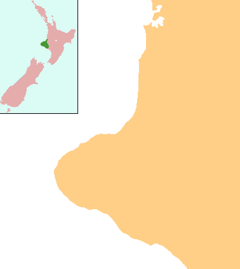
Midhirst is a small village in Taranaki, New Zealand, approximately 4 km north of Stratford, on State Highway 3. Inglewood is 17 km (11 mi) north of Midhirst, and New Plymouth is 35 km (22 mi) to the northwest.[1][2]
Midhirst | |
|---|---|
 Midhirst | |
| Coordinates: 39°17′36″S 174°15′59″E | |
| Country | New Zealand |
| Region | Taranaki |
| District | Stratford District |
| Population (2013) | |
| • Total | 234 |
According to the 2013 New Zealand census, Midhirst has a population of 234, an increase of 9 people since the 2006 census.[3] Midhirst is home to Midhirst School, the Midhirst Tavern, and a number of other local businesses.
Education
Midhirst School is a coeducational full primary (years 1-8) school with a roll of 126 students as of March 2020.[4][5] The school was founded in 1880.[6]
Notes
- Peter Dowling (editor) (2004), Reed New Zealand Atlas, Reed Books, pp. map 34, ISBN 0-7900-0952-8CS1 maint: extra text: authors list (link)
- Roger Smith, GeographX (2005), The Geographic Atlas of New Zealand, Robbie Burton, pp. map 85, ISBN 1-877333-20-4
- 2013 Census QuickStats about a place : Midhirst
- "New Zealand Schools Directory". New Zealand Ministry of Education. Retrieved 26 April 2020.
- Education Counts: Midhirst School
- "Midhirst School 125th Jubilee", Education Gazette New Zealand, 83 (17), 13 September 2004, archived from the original on 16 October 2008
gollark: Basically that.
gollark: I don't see why you would need any hardware for this.
gollark: Using an existing custom ROM thing is very easy, compiling Android yourself is hard and extremely slow because Android is horribly designed, porting postmarketOS is probably harder but at least not glacially slow.
gollark: What?
gollark: In many cases there are custom ROMs available (without google apps and stuff) though.
External links
Further reading
General historical works
- Alsop, Nancy; et al. (1981), Midhirst School and districts centennial, 1880-1980, Midhirst, [N.Z.] ; Stratford, [N.Z.]: Jubilee Committee ; Stratford Press
- Youngman, Reeve (1965), Perhaps-ies: early days Canterbury and Taranaki, Mt. Maunganui, [N.Z.] ; Hastings, [N.Z.]: R. Youngman ; Hart Printing
Business history
- Midhirst Dairy Company, 1895-1945, : Midhirst, [N.Z.]: Midhirst Co-operative Dairy Factory Company, 1945
- Midhirst Dairy Company, 1895-1970, : Midhirst, [N.Z.]: n.p., 1970
Maps
- New Zealand Minimaps Ltd. (2000), Kiwi minimap New Plymouth, 20 Taranaki towns & district map: includes: Eltham, Hawera, Inglewood, Kaponga, Lepperton, Manaia, Midhirst, Mokau, Normanby, Oakura, Ohawe Beach, Okato, Onaero, Opunake, Patea, Rahotu, Stratford, Urenui, Waitara, Waitotara & Waverley. (4th ed.), Christchurch, [N.Z.]: Minimaps Ltd.
NOTE: Scale = 1:35,000 and 1:275,000
- New Zealand Minimaps Ltd. (2001), Kiwi minimap New Plymouth, 20 Taranaki towns & district map: includes: Eltham, Hawera, Inglewood, Kaponga, Lepperton, Manaia, Midhirst, Mokau, Normanby, Oakura, Ohawe Beach, Okato, Onaero, Opunake, Patea, Rahotu, Stratford, Urenui, Waitara, Waitotara & Waverley. (5th ed.), Christchurch, [N.Z.]: Minimaps Ltd.
NOTE: Scale = 1:35,000 and 1:275,000
Schools
- Midhirst School: 75th anniversary 1880-1955; jubilee celebrations, October 22nd, 23rd and 24th, 1955, n.p.: n.p., n.d.
- Alsop, Nancy; et al. (1981), Midhirst School and districts centennial, 1880-1980, Midhirst, [N.Z.] ; Stratford, [N.Z.]: Jubilee Committee ; Stratford Press
This article is issued from Wikipedia. The text is licensed under Creative Commons - Attribution - Sharealike. Additional terms may apply for the media files.