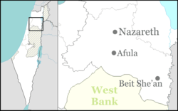
Meitav, Israel
Meitav (Hebrew: מֵיטָב, lit. Utmost, best) is a moshav in north-eastern Israel. Located in the Ta'anakh region, it falls under the jurisdiction of Gilboa Regional Council. In 2019 it had a population of 471.[1]
Meitav | |
|---|---|
Village office | |
 Meitav | |
| Coordinates: 32°32′48.47″N 35°18′2.16″E | |
| Country | Israel |
| District | Northern |
| Council | Gilboa |
| Affiliation | Moshavim Movement |
| Founded | 1954 |
| Founded by | Kurdish and Iranian immigrants |
| Population (2019)[1] | 471 |
History
The moshav was established in 1954 by immigrants from Kurdistan and Iraq on the land of the depopulated Palestinian village of Al-Mazar.[2] The third settlement to be founded in the Ta'anakh, it was initially named Ta'anakh Gimel (lit. Ta'anakh 3). The name derives from Bereshit/Genesis 47,11: "Joseph ... gave them property in the best part of the land."[3][4]
gollark: (if you are not aware of minoteaur, "ambi", please use the search option)
gollark: To make M(inoteaur|acron).
gollark: And Minoteaur. MAKE MINOTEAUR. I cannot, apparently, do this → it is your problem → do so → bees rotate → do so.
gollark: Why didn't you make Macron?
gollark: I've always thought it would be easier a lot of the time to just cancel the ds in the fraction.
References
- "Population in the Localities 2019" (XLS). Israel Central Bureau of Statistics. Retrieved 16 August 2020.
- Khalidi, W. (1992). All That Remains: The Palestinian Villages Occupied and Depopulated by Israel in 1948. Washington D.C.: Institute for Palestine Studies. p. 337. ISBN 0-88728-224-5.
- Carta's Official Guide to Israel and Complete Gazetteer to all Sites in the Holy Land. (3rd edition 1993) Jerusalem, Carta, p.324 ISBN 965-220-186-3
- Bitan, Hanna: 1948-1998: Fifty Years of 'Hityashvut': Atlas of Names of Settlements in Israel, Jerusalem 1999, Carta, p.39 (in Hebrew) ISBN 965-220-423-4
This article is issued from Wikipedia. The text is licensed under Creative Commons - Attribution - Sharealike. Additional terms may apply for the media files.