Merrion Street
Merrion Street (/ˈmɛriːən/; Irish: Sráid Mhuirfean) is a major Georgian street on the southside of Dublin, Ireland, which runs along one side of Merrion Square. It is divided into Merrion Street Lower (north end), Merrion Square West and Merrion Street Upper (south end).
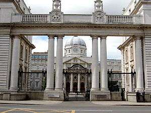 Government Buildings in Merrion Street, formerly the Royal College of Science | |
 | |
| Native name | Sráid Mhuirfean (Irish) |
|---|---|
| Namesake | Merrion Castle, seat of the Viscounts FitzWilliam |
| Length | 450 m (1,480 ft) |
| Width | 30 metres (98 ft) |
| Location | Dublin, Ireland |
| Postal code | D02 |
| Coordinates | 53°20′20″N 6°15′10″W |
| north end | Lincoln Place, Fenian Street |
| south end | Merrion Row, Ely Place, Baggot Street Lower |
| Other | |
| Known for | Government Buildings, Georgian architecture |
The garden entrance of Leinster House is located on the street, as is Irish Government Buildings, formerly the Royal College of Science for Ireland. Some reports suggest that Field Marshal The 1st Duke of Wellington was born in his family's Mornington House on the street. The house is now a hotel.
The street was originally lined on both sides by Georgian houses. However between 1904 and 1922 all the houses on one side of the street were demolished and replaced by the Royal College of Science for Ireland, which was designed by Sir Aston Webb.
The term "Merrion Street" is often used as shorthand for Irish Government in the same way as Whitehall or Downing Street is used to refer to the British government. The official Irish Government news service website is called merrionstreet.ie.[1]
References
- "About: MerrionStreet.ie Irish Government News Service". merrionstreet.ie. 2011-03-09. Retrieved 2011-06-24.