Mechi Highway
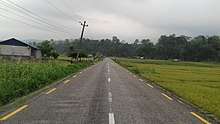
Mechi Highway (Nepali: मेची राजमार्ग) is a two-lane freeway in Eastern Nepal, spanning about 268 kilometers in length.[1] The highway connects all the districts of Mechi zone, hence the name Mechi. It runs from the VDC of Kechana in Jhapa district in the south to the remote north of Taplejung through the district of Ilam.[1] The main destinations along the highway include Prithivinagar, Bhadrapur, Duhagadhi, Budhabare, Kanyam, and Phikkal. The highway shares a junction with Mahendra Highway at Charali.[2]
| ||||
|---|---|---|---|---|
| मेची राजमार्ग | ||||
| Mechi Highway | ||||
| Route information | ||||
| Maintained by MoPIT (Department of Roads) | ||||
| Length | 268 km (167 mi) | |||
| Major junctions | ||||
| South end | Kechana | |||
| North end | Taplejung | |||
| Location | ||||
| Primary destinations | Prithivinagar, Bhadrapur, Duhagadhi, Budhabare, Kanyam, Phikkal | |||
| Highway system | ||||
Roads in Nepal
| ||||
References
- "List of National Highways". dor.gov.np. Department of Roads, Ministry of Physical Infrastructure & Transport, Government of Nepal. Archived from the original on 9 July 2016. Retrieved 25 June 2016.
- "Map of Mechi Highway". Google Maps. Google. Retrieved 25 June 2016.
This article is issued from Wikipedia. The text is licensed under Creative Commons - Attribution - Sharealike. Additional terms may apply for the media files.

