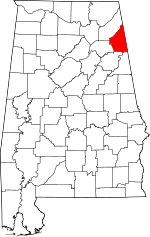
McCord Crossroads, Alabama
McCords Crossroads (formerly, Hopewell) is an unincorporated community in Cherokee County, Alabama, United States. It lies at an elevation of 640 feet (195 m).
McCord Crossroads | |
|---|---|
 McCord Crossroads Location in Alabama. | |
| Coordinates: 34°06′59″N 85°27′35″W | |
| Country | United States |
| State | Alabama |
| County | Cherokee |
| Elevation | 640 ft (200 m) |
| Time zone | UTC-6 (Central (CST)) |
| • Summer (DST) | UTC-5 (CDT) |
| Area code(s) | 256 & 938 |
| GNIS feature ID | 152269[1] |
History
McCord Crossroads was named in honor of James McCord.[2]
gollark: Especially if you want working JS, CSS, videos etc.
gollark: Browsers are very complex.
gollark: Well:- It's Java, I don't like Java- You'll have to maintain two insanely complex codebases
gollark: PotatOS = potatoS = potatOS = POTATos
gollark: It's both.
References
- "McCord Crossroads". Geographic Names Information System. United States Geological Survey.
- "Cherokee County, Ala". Calhoun Times. September 1, 2004. p. 45. Retrieved 24 April 2015.
This article is issued from Wikipedia. The text is licensed under Creative Commons - Attribution - Sharealike. Additional terms may apply for the media files.
