Mauerstetten
Mauerstetten is a municipality in the district of Ostallgäu in the southwest of Bavaria in Germany.
Mauerstetten | |
|---|---|
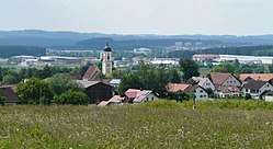 Mauerstetten seen from the east | |
 Coat of arms | |
Location of Mauerstetten within Ostallgäu district 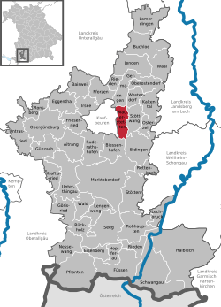 | |
 Mauerstetten  Mauerstetten | |
| Coordinates: 47°53′N 10°40′E | |
| Country | Germany |
| State | Bavaria |
| Admin. region | Schwaben |
| District | Ostallgäu |
| Government | |
| • Mayor | Armin Holderried (FW) |
| Area | |
| • Total | 16.55 km2 (6.39 sq mi) |
| Elevation | 716 m (2,349 ft) |
| Population (2018-12-31)[1] | |
| • Total | 3,154 |
| • Density | 190/km2 (490/sq mi) |
| Time zone | CET/CEST (UTC+1/+2) |
| Postal codes | 87665 |
| Dialling codes | 08341 |
| Vehicle registration | OAL |
| Website | www.mauerstetten.de |
Its foundations dates back to the early 9th century, and its name actually means "place of walls", due to ruins of supposedly Roman origin found there. Currently, Mauerstetten has about 2,800 inhabitants living in the four parts of the community: Mauerstetten itself, Steinholz, Hausen and Frankenried. Agriculture still plays a large role in the village, but some modest industry is to be found there as well.
The village has a primary school, a kindergarten, two banks (Sparkasse and RaiBa), a small grocery store, a bakery, and a small post office. In the center of Mauerstetten stands the church St. Vitus.
References
- "Fortschreibung des Bevölkerungsstandes". Bayerisches Landesamt für Statistik und Datenverarbeitung (in German). July 2019.
External links
Towns and municipalities in Ostallgäu | ||
|---|---|---|
| Coat of Arms of Ostallgäu district | |
| Authority control |
|
|---|
This article is issued from Wikipedia. The text is licensed under Creative Commons - Attribution - Sharealike. Additional terms may apply for the media files.