Matta (river)
The Matta (Russian: Матта) is a river in the Sakha Republic, Russia. It is a left tributary of the Sinyaya. It is 195 kilometres (121 mi) long, and has a drainage basin of 4,110 square kilometres (1,590 sq mi).[1]
| Matta Yakut: Матта | |
|---|---|
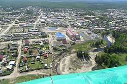 View of the river on the right at Berdigestyakh | |
 Location in the Sakha Republic, Russia | |
| Location | |
| Country | Sakha, Russia |
| Physical characteristics | |
| Source | |
| • location | Lena Plateau |
| • coordinates | 62°13′32″N 126°59′12″E |
| Mouth | |
• location | Sinyaya |
• coordinates | 61.5319°N 126.3242°E |
• elevation | 157 m (515 ft) |
| Length | 195 km (121 mi) |
| Basin size | 4,110 km2 (1,590 sq mi) |
| Discharge | |
| • average | 1.19 m3/s (42 cu ft/s) |
| Basin features | |
| Progression | Sinyaya→ Lena→ Laptev Sea |
Course
The river begins in the southern area of the Lena Plateau. It flows roughly northeastwards across Gorny District and there are about 300 lakes in its basin. The town of Berdigestyakh is located by the river. The Matta meets the left bank of the Sinyaya, a tributary of the Lena, 118 km (73 mi) upstream from its mouth.[2] There is also a reservoir on the river that is named after it.[3]
The main tributary of the Matta is the 67 km (42 mi) long Dugda on the left.[2]
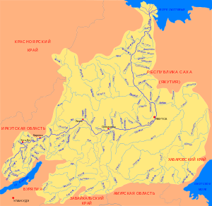 Basin of the Lena |
gollark: Looks like you should have a security terminal. Or doors.
gollark: Oh dear.
gollark: Okay, turns out I don't care either way.
gollark: Unless it's an uninteresting thing.
gollark: Time to USELESSLY COMMENT ON A PR!
See also
References
- Река Маатта (Матта) in the State Water Register of Russia (Russian)
- Matta // Great Soviet Encyclopedia, in 30 vols. / Ch. ed. A.M. Prokhorov . - 3rd ed. - M .: Soviet Encyclopedia, 1969-197
- Google Earth
External links

- Geography - Yakutia Organized
This article is issued from Wikipedia. The text is licensed under Creative Commons - Attribution - Sharealike. Additional terms may apply for the media files.