Matsubara, Osaka
Matsubara (松原市, Matsubara-shi) is a city located in Osaka Prefecture, Japan.
Matsubara 松原市 | |
|---|---|
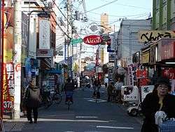 Kawachiamami Street in Matsubara | |
 Flag  Emblem | |
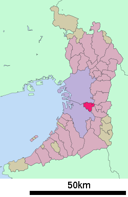 Location of Matsubara in Osaka Prefecture | |
 Matsubara Location in Japan | |
| Coordinates: 34°35′N 135°33′E | |
| Country | Japan |
| Region | Kansai |
| Prefecture | Osaka Prefecture |
| Government | |
| • Mayor | Takanori Nakano |
| Area | |
| • Total | 16.66 km2 (6.43 sq mi) |
| Population (March 31, 2017) | |
| • Total | 121,125 |
| • Density | 7,300/km2 (19,000/sq mi) |
| Symbols | |
| • Tree | Pine (Matsu) |
| • Flower | Rose (Bara) |
| Time zone | UTC+9 (JST) |
| City hall address | 1-1-1 Ao, Matsubara-shi, Ōsaka-fu 580-8501 |
| Website | www |
As of 2017, the city has an estimated population of 121,125 and a population density of 7,300 persons per km².[1] The total area is 16.66 km².
Hannan University is located in Matsubara. Hannan University is a mid-sized liberal arts university with a focus on business and technology.
History
In the 5th century AD, Emperor Hanzei is believed to have had his palace, Tajihi Shibagaki-no-Miya (丹比柴籬宮), in the area. The area that now comprises Matsubara was located in the historical Kawachi Province, which is still considered the (non-municipal) subregion to which it belongs. During the Edo period, Matsubara was the administrative center of the Tannan Domain (丹南藩, -han), whose Tannan Encampment was located in present-day Tannan, Matsubara City.
- 1889 (Meiji 22), April 1: The villages of Matsubara, Amami, Nunose, Miyake, and Ega are designated as part of Tanboku District.
- 1896 (Meiji 29), April 1: Naka-Kawachi District is created, consolidated from the former districts of Tanboku, Takayasu, Ōgata, Kawachi, Wakae, and Shibukawa. The above villages thus become part of Naka-Kawachi District.
- 1942 (Shōwa 17), July 1: The village of Matsubara is promoted to Town status, becoming Matsubara-chō, Naka-Kawachi District.
- 1947 (Shōwa 22), January 1: The village of Amami is promoted to Town status, becoming Amami-chō, Naka-Kawachi District.
- 1955 (Shōwa 30), February 1: The towns of Matsubara and Amami, along with the villages of Nunose, Miyake, and Ega, are consolidated into Matsubara City, Osaka Prefecture's 21st city.
- 1957 (Shōwa 32)
- April 1: Matsubara incorporated the Tannan area of Mihara-chō, Minami-Kawachi District (now Mihara-ku, Sakai).
- October 15: Matsubara incorporated the Kawai area of Kita-Yashimo Village, Minami-Kawachi District
- 1964 (Shōwa 39): The Kita-Wakabayashi area was made part of Yao City.
Geography
Adjacent municipalities
- Osaka Prefecture
- Osaka (Sumiyoshi-ku, Higashi Sumiyoshi-ku, Hirano-ku)
- Sakai (Kita-ku, Mihara-ku)
- Yao
- Fujiidera
- Habikino
Friendship municipalities
In Japan
- Tsukigase-mura, Yamabe District, Nara (now part of Nara City)
- Friendship agreement since September 7, 1985
References
- "Official website of Matsubara city" (in Japanese). Retrieved April 6, 2017.
External links
- Official website (in Japanese)
Osaka (capital) | ||||
| Osaka |
| |||
| Sakai |
| |||
| Core cities |
| |||
| Special cities | ||||
| Cities | ||||
| Districts | ||||
List of mergers in Osaka Prefecture; Note: ☆ - Cities to become core cities | ||||
| Authority control |
|
|---|