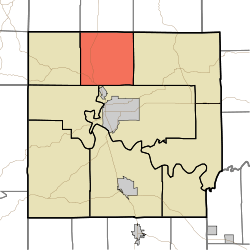
Marshall Township, Lawrence County, Indiana
Marshall Township is one of nine townships in Lawrence County, Indiana, United States. As of the 2010 census, its population was 4,660 and it contained 2,038 housing units.[2]
Marshall Township | |
|---|---|
 Location in Lawrence County | |
| Coordinates: 38°56′34″N 86°30′53″W | |
| Country | |
| State | |
| County | Lawrence |
| Government | |
| • Type | Indiana township |
| • Trustee | Suzi Evans[1] |
| Area | |
| • Total | 36.33 sq mi (94.1 km2) |
| • Land | 36.32 sq mi (94.1 km2) |
| • Water | 0.01 sq mi (0.03 km2) 0.03% |
| Elevation | 495 ft (151 m) |
| Population (2010) | |
| • Total | 4,660 |
| • Density | 128.3/sq mi (49.5/km2) |
| ZIP codes | 47420, 47421, 47451, 47462 |
| GNIS feature ID | 0453615 |
History
Marshall Township was named for John Marshall, fourth Chief Justice of the United States.[3]
Geography
According to the 2010 census, the township has a total area of 36.33 square miles (94.1 km2), of which 36.32 square miles (94.1 km2) (or 99.97%) is land and 0.01 square miles (0.026 km2) (or 0.03%) is water.[2]
Unincorporated towns
- Avoca at 38.911994°N 86.547773°W
- Coveyville at 38.973383°N 86.472494°W
- Guthrie at 38.976716°N 86.509161°W
- Judah at 38.960882°N 86.537218°W
- Logan at 38.942272°N 86.50805°W
- Murdock at 38.909772°N 86.508327°W
- Needmore at 38.927272°N 86.529995°W
- Peerless at 38.924494°N 86.503327°W
- Stemm at 38.956994°N 86.504161°W
- Thornton at 38.916717°N 86.501383°W
(This list is based on USGS data and may include former settlements.)
Cemeteries
The township contains these six cemeteries: Anderson, Brinegar, Hayes, Hopkins, Mount Zion and Perkins.
Major highways
School districts
- North Lawrence Community Schools
Political districts
- Indiana's 4th congressional district
- State House District 65
- State Senate District 44
gollark: I suppose the native APIs would count, and you can't really do anything without those.
gollark: Wow, I dislike the GPL now.
gollark: Although the second paragraph means it might, hm.
gollark: https://www.gnu.org/licenses/gpl-faq.html#IfInterpreterIsGPL
gollark: I don't *think* it would work as you think, anyway.
References
- "Marshall Township, Lawrence County, Indiana". Geographic Names Information System. United States Geological Survey. Retrieved 2009-10-08.
- United States Census Bureau 2008 TIGER/Line Shapefiles
- IndianaMap
- https://lawrencecounty.in.gov/government/township-trustees
- "Population, Housing Units, Area, and Density: 2010 - County -- County Subdivision and Place -- 2010 Census Summary File 1". United States Census. Archived from the original on 2020-02-12. Retrieved 2013-05-10.
- History of Lawrence and Monroe Counties, Indiana: Their People, Industries, and Institutions. B.F. Bowen. 1914. pp. 47.
External links
This article is issued from Wikipedia. The text is licensed under Creative Commons - Attribution - Sharealike. Additional terms may apply for the media files.