Maritime radionavigation-satellite service
Maritime radionavigation-satellite service (short: MRNSS) is – according to Article 1.45 of the International Telecommunication Union's (ITU) Radio Regulations (RR)[1] – defined as «A radionavigation-satellite service in which earth stations are located on board ships.»
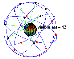
GPS Radionavigation-satellite service
This service is a so-called safety-of-life service, must be protected for Interferences, and is essential part of Navigation.
- See also
Classification
This radiocommunication service is classified in accordance with ITU Radio Regulations (article 1) as follows:
Radiodetermination service (article 1.40)
- Radionavigation service (article 1.42)
- Radionavigation-satellite service (article 1.43)
- Maritime radionavigation service (article 1.44)
- Maritime radionavigation-satellite service
- Aeronautical radionavigation service (article 1.46)
- Aeronautical radionavigation-satellite service (article 1.47)
Radio stations
In general the maritime radionavigation service distinguishes radio stations as follows:
- Radionavigation mobile stations (article 1.87)
- Satellite system (article 1.110)
- Space system (article 1.111)
- Feeder links (article 1.115)
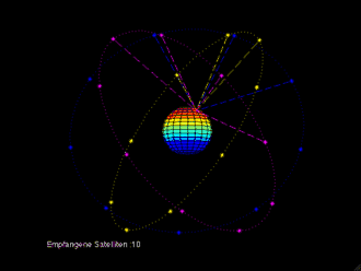
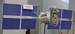
Examples of MRNSS stations / systems:
References / sources
- ITU Radio Regulations, Section IV. Radio Stations and Systems – Article 1.45, definition: maritime radionavigation-satellite service
| Fixed services | |
|---|---|
| Mobile services | Mobile-satellite … | Land mobile … • Land mobile-satellite … |
Maritime mobile … • Maritime mobile-satellite … • Port operations … • Ship movement … | Aeronautical mobile … • Aeronautical mobile (R) … • Aeronautical mobile (OR) … | Aeronautical mobile-satellite … • Aeronautical mobile-satellite (R) … • Aeronautical mobile-satellite (OR) service |
| Radio- determination services | Radiodetermination-satellite … |
Radionavigation … • Radionavigation-satellite … • Maritime radionavigation … • Maritime radionavigation-satellite … • Aeronautical radionavigation … • Aeronautical radionavigation-satellite … | Radiolocation … • Radiolocation-satellite service |
| other services | Space operation … | Broadcasting … • Broadcasting-satellite … |
Meteorological aids … | Standard frequency and time signal … • Standard frequency and time signal-satellite … | Space research … | Amateur … • Amateur-satellite … | Radio astronomy … | Safety … | Special service |
| |
gollark: <:chips:453465151132139521><:chips:453465151132139521><:chips:453465151132139521><:chips:453465151132139521><:chips:453465151132139521><:chips:453465151132139521><:chips:453465151132139521><:chips:453465151132139521><:chips:453465151132139521><:chips:453465151132139521><:chips:453465151132139521><:chips:453465151132139521><:chips:453465151132139521><:chips:453465151132139521><:chips:453465151132139521><:chips:453465151132139521><:chips:453465151132139521><:chips:453465151132139521><:chips:453465151132139521><:chips:453465151132139521><:chips:453465151132139521><:chips:453465151132139521><:chips:453465151132139521><:chips:453465151132139521><:chips:453465151132139521><:chips:453465151132139521><:chips:453465151132139521><:chips:453465151132139521><:chips:453465151132139521><:chips:453465151132139521><:chips:453465151132139521><:chips:453465151132139521><:chips:453465151132139521><:chips:453465151132139521><:chips:453465151132139521><:chips:453465151132139521><:chips:453465151132139521><:chips:453465151132139521><:chips:453465151132139521><:chips:453465151132139521><:chips:453465151132139521><:chips:453465151132139521><:chips:453465151132139521><:chips:453465151132139521><:chips:453465151132139521><:chips:453465151132139521><:chips:453465151132139521><:chips:453465151132139521><:chips:453465151132139521><:chips:453465151132139521><:chips:453465151132139521><:chips:453465151132139521><:chips:453465151132139521><:chips:453465151132139521><:chips:453465151132139521><:chips:453465151132139521><:chips:453465151132139521><:chips:453465151132139521><:chips:453465151132139521><:chips:453465151132139521><:chips:453465151132139521><:chips:453465151132139521><:chips:453465151132139521><:chips:453465151132139521><:chips:453465151132139521><:chips:453465151132139521><:chips:453465151132139521><:chips:453465151132139521><:chips:453465151132139521><:chips:453465151132139521><:chips:453465151132139521><:chips:453465151132139521><:chips:453465151132139521><:chips:453465151132139521>
gollark: <:chips:453465151132139521><:chips:453465151132139521><:chips:453465151132139521><:chips:453465151132139521><:chips:453465151132139521><:chips:453465151132139521><:chips:453465151132139521><:chips:453465151132139521><:chips:453465151132139521><:chips:453465151132139521><:chips:453465151132139521><:chips:453465151132139521><:chips:453465151132139521><:chips:453465151132139521><:chips:453465151132139521><:chips:453465151132139521><:chips:453465151132139521><:chips:453465151132139521><:chips:453465151132139521><:chips:453465151132139521><:chips:453465151132139521><:chips:453465151132139521><:chips:453465151132139521><:chips:453465151132139521><:chips:453465151132139521><:chips:453465151132139521><:chips:453465151132139521><:chips:453465151132139521><:chips:453465151132139521><:chips:453465151132139521><:chips:453465151132139521><:chips:453465151132139521><:chips:453465151132139521><:chips:453465151132139521><:chips:453465151132139521><:chips:453465151132139521><:chips:453465151132139521><:chips:453465151132139521><:chips:453465151132139521><:chips:453465151132139521><:chips:453465151132139521><:chips:453465151132139521><:chips:453465151132139521><:chips:453465151132139521><:chips:453465151132139521><:chips:453465151132139521><:chips:453465151132139521><:chips:453465151132139521><:chips:453465151132139521><:chips:453465151132139521><:chips:453465151132139521><:chips:453465151132139521><:chips:453465151132139521><:chips:453465151132139521><:chips:453465151132139521><:chips:453465151132139521><:chips:453465151132139521><:chips:453465151132139521><:chips:453465151132139521><:chips:453465151132139521><:chips:453465151132139521><:chips:453465151132139521><:chips:453465151132139521><:chips:453465151132139521><:chips:453465151132139521><:chips:453465151132139521><:chips:453465151132139521><:chips:453465151132139521><:chips:453465151132139521><:chips:453465151132139521><:chips:453465151132139521><:chips:453465151132139521><:chips:453465151132139521><:chips:453465151132139521>
gollark: <:chips:453465151132139521><:chips:453465151132139521><:chips:453465151132139521><:chips:453465151132139521><:chips:453465151132139521><:chips:453465151132139521><:chips:453465151132139521><:chips:453465151132139521><:chips:453465151132139521><:chips:453465151132139521><:chips:453465151132139521><:chips:453465151132139521><:chips:453465151132139521><:chips:453465151132139521><:chips:453465151132139521><:chips:453465151132139521><:chips:453465151132139521><:chips:453465151132139521><:chips:453465151132139521><:chips:453465151132139521><:chips:453465151132139521><:chips:453465151132139521><:chips:453465151132139521><:chips:453465151132139521><:chips:453465151132139521><:chips:453465151132139521><:chips:453465151132139521><:chips:453465151132139521><:chips:453465151132139521><:chips:453465151132139521><:chips:453465151132139521><:chips:453465151132139521><:chips:453465151132139521><:chips:453465151132139521><:chips:453465151132139521><:chips:453465151132139521><:chips:453465151132139521><:chips:453465151132139521><:chips:453465151132139521><:chips:453465151132139521><:chips:453465151132139521><:chips:453465151132139521><:chips:453465151132139521><:chips:453465151132139521><:chips:453465151132139521><:chips:453465151132139521><:chips:453465151132139521><:chips:453465151132139521><:chips:453465151132139521><:chips:453465151132139521><:chips:453465151132139521><:chips:453465151132139521><:chips:453465151132139521><:chips:453465151132139521><:chips:453465151132139521><:chips:453465151132139521><:chips:453465151132139521><:chips:453465151132139521><:chips:453465151132139521><:chips:453465151132139521><:chips:453465151132139521><:chips:453465151132139521><:chips:453465151132139521><:chips:453465151132139521><:chips:453465151132139521><:chips:453465151132139521><:chips:453465151132139521><:chips:453465151132139521><:chips:453465151132139521><:chips:453465151132139521><:chips:453465151132139521><:chips:453465151132139521><:chips:453465151132139521><:chips:453465151132139521>
gollark: <:chips:453465151132139521><:chips:453465151132139521><:chips:453465151132139521><:chips:453465151132139521><:chips:453465151132139521><:chips:453465151132139521><:chips:453465151132139521><:chips:453465151132139521><:chips:453465151132139521><:chips:453465151132139521><:chips:453465151132139521><:chips:453465151132139521><:chips:453465151132139521><:chips:453465151132139521><:chips:453465151132139521><:chips:453465151132139521><:chips:453465151132139521><:chips:453465151132139521><:chips:453465151132139521><:chips:453465151132139521><:chips:453465151132139521><:chips:453465151132139521><:chips:453465151132139521><:chips:453465151132139521><:chips:453465151132139521><:chips:453465151132139521><:chips:453465151132139521><:chips:453465151132139521><:chips:453465151132139521><:chips:453465151132139521><:chips:453465151132139521><:chips:453465151132139521><:chips:453465151132139521><:chips:453465151132139521><:chips:453465151132139521><:chips:453465151132139521><:chips:453465151132139521><:chips:453465151132139521><:chips:453465151132139521><:chips:453465151132139521><:chips:453465151132139521><:chips:453465151132139521><:chips:453465151132139521><:chips:453465151132139521><:chips:453465151132139521><:chips:453465151132139521><:chips:453465151132139521><:chips:453465151132139521><:chips:453465151132139521><:chips:453465151132139521><:chips:453465151132139521><:chips:453465151132139521><:chips:453465151132139521><:chips:453465151132139521><:chips:453465151132139521><:chips:453465151132139521><:chips:453465151132139521><:chips:453465151132139521><:chips:453465151132139521><:chips:453465151132139521><:chips:453465151132139521><:chips:453465151132139521><:chips:453465151132139521><:chips:453465151132139521><:chips:453465151132139521><:chips:453465151132139521><:chips:453465151132139521><:chips:453465151132139521><:chips:453465151132139521><:chips:453465151132139521><:chips:453465151132139521><:chips:453465151132139521><:chips:453465151132139521><:chips:453465151132139521>
gollark: <:chips:453465151132139521><:chips:453465151132139521><:chips:453465151132139521><:chips:453465151132139521><:chips:453465151132139521><:chips:453465151132139521><:chips:453465151132139521><:chips:453465151132139521><:chips:453465151132139521><:chips:453465151132139521><:chips:453465151132139521><:chips:453465151132139521><:chips:453465151132139521><:chips:453465151132139521><:chips:453465151132139521><:chips:453465151132139521><:chips:453465151132139521><:chips:453465151132139521><:chips:453465151132139521><:chips:453465151132139521><:chips:453465151132139521><:chips:453465151132139521><:chips:453465151132139521><:chips:453465151132139521><:chips:453465151132139521><:chips:453465151132139521><:chips:453465151132139521><:chips:453465151132139521><:chips:453465151132139521><:chips:453465151132139521><:chips:453465151132139521><:chips:453465151132139521><:chips:453465151132139521><:chips:453465151132139521><:chips:453465151132139521><:chips:453465151132139521><:chips:453465151132139521><:chips:453465151132139521><:chips:453465151132139521><:chips:453465151132139521><:chips:453465151132139521><:chips:453465151132139521><:chips:453465151132139521><:chips:453465151132139521><:chips:453465151132139521><:chips:453465151132139521><:chips:453465151132139521><:chips:453465151132139521><:chips:453465151132139521><:chips:453465151132139521><:chips:453465151132139521><:chips:453465151132139521><:chips:453465151132139521><:chips:453465151132139521><:chips:453465151132139521><:chips:453465151132139521><:chips:453465151132139521><:chips:453465151132139521><:chips:453465151132139521><:chips:453465151132139521><:chips:453465151132139521><:chips:453465151132139521><:chips:453465151132139521><:chips:453465151132139521><:chips:453465151132139521><:chips:453465151132139521><:chips:453465151132139521><:chips:453465151132139521><:chips:453465151132139521><:chips:453465151132139521><:chips:453465151132139521><:chips:453465151132139521><:chips:453465151132139521><:chips:453465151132139521>
This article is issued from Wikipedia. The text is licensed under Creative Commons - Attribution - Sharealike. Additional terms may apply for the media files.