Nonnweiler
Nonnweiler is a municipality in the district of Sankt Wendel, in Saarland, Germany.
Nonnweiler | |
|---|---|
 | |
 Coat of arms | |
Location of Nonnweiler within Sankt Wendel district 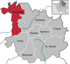  | |
 Nonnweiler  Nonnweiler | |
| Coordinates: 49°37′N 6°57′E | |
| Country | Germany |
| State | Saarland |
| District | Sankt Wendel |
| Subdivisions | 8 |
| Government | |
| • Mayor | Hans-Uwe Schneider (CDU) |
| Area | |
| • Total | 66.71 km2 (25.76 sq mi) |
| Elevation | 414 m (1,358 ft) |
| Population (2018-12-31)[1] | |
| • Total | 8,477 |
| • Density | 130/km2 (330/sq mi) |
| Time zone | CET/CEST (UTC+1/+2) |
| Postal codes | 66616–66620 |
| Dialling codes | 06873 |
| Vehicle registration | WND |
| Website | www.nonnweiler.de |
Overview
It is situated approximately 20 km northwest of Sankt Wendel, and 30 km southeast of Trier.
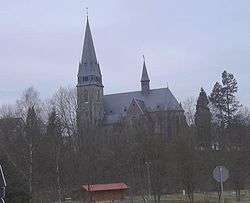
The village is well known for the "Hillfort of Otzenhausen", a huge wall (former castle) of Celtic origin.
gollark: It can communicate over SPUDNET, so you can install Monopsony terminals in remote locations with only an ender chest link.
gollark: Also a vaguely working GUI with less wasted space than Milo's.
gollark: Yes, it has good features.
gollark: It is not recommended for public use due to [REDACTED] and also the lack of autocrafting.
gollark: Monopsony™ by GTech™ is a storage system.
References
- "Saarland.de – Amtliche Einwohnerzahlen Stand 31.12.2018" (PDF). Statistisches Amt des Saarlandes (in German). June 2019.
Towns and municipalities in Sankt Wendel (district) | ||
|---|---|---|
Coat of arms | ||
| Authority control |
|
|---|
This article is issued from Wikipedia. The text is licensed under Creative Commons - Attribution - Sharealike. Additional terms may apply for the media files.