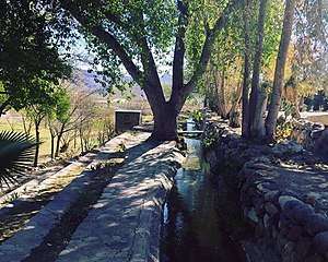
Manuel Benavides Municipality
Manuel Benavides is one of the 67 municipalities of Chihuahua, in northern Mexico. The municipal seat lies at Manuel Benavides village. The municipality covers an area of 3,191.5 km².
Manuel Benavides | |
|---|---|
Municipality | |
 | |
 Municipality of Manuel Benavides in Chihuahua | |
 Manuel Benavides Location in Mexico | |
| Coordinates: 29°06′26″N 103°54′23″W | |
| Country | |
| State | Chihuahua |
| Municipal seat | Manuel Benavides |
| Area | |
| • Total | 3,191.5 km2 (1,232.2 sq mi) |
| Population (2010) | |
| • Total | 1,601 |
| • Density | 0.50/km2 (1.3/sq mi) |
As of the 2010 census, the municipality had a total population of 1,601 .[1][2]
The municipality had 183 localities, none of which had a population over 1,000.[2]
Geography
Towns and villages
The municipality has 115 localities. The largest are:
| Name | 2010 Census Population | |
|---|---|---|
| Manuel Benavides | 916 | |
| Álamos de San Antonio | 131 | |
| Paso de San Antonio (La Hacienda) | 81 | |
| Nuevo Lajitas | 65 | |
| Escobillas de Abajo | 46 | |
| Total Municipality | 1,601 |
Adjacent municipalities and counties
- Ocampo Municipality, Coahuila - east
- Camargo Municipality - south
- Ojinaga Municipality - west
- Presidio County, Texas - north
- Brewster County, Texas - northeast
gollark: All the fun stuff is.
gollark: What could you possibly be doing which somehow breaks support for particular GPUs?
gollark: The Rust toml parser thing via serde does actually verify the types, too.
gollark: Or `break`.
gollark: The `Run` option in `edit` uses `.temp`, <@!175686996461617162>, so yes.
References
- 2010 census tables: INEGI Archived 2013-05-02 at the Wayback Machine accessdate=April 29, 2011
- "Manuel Benavides". Catálogo de Localidades. Secretaría de Desarrollo Social (SEDESOL). Retrieved 23 April 2014.
This article is issued from Wikipedia. The text is licensed under Creative Commons - Attribution - Sharealike. Additional terms may apply for the media files.
