Manning, Kansas
Manning is an unincorporated community in Scott County, Kansas, United States.[1]
Manning, Kansas | |
|---|---|
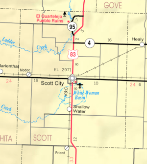 KDOT map of Scott County (legend) | |
 Manning  Manning | |
| Coordinates: 38°33′19″N 100°43′25″W[1] | |
| Country | United States |
| State | Kansas |
| County | Scott |
| Elevation | 3,136 ft (956 m) |
| Time zone | UTC-6 (CST) |
| • Summer (DST) | UTC-5 (CDT) |
| Area code | 620 |
| FIPS code | 20-44325 [1] |
| GNIS ID | 471466 [1] |
History
A post office was opened in Manning on December 20, 1887, and remained in operation until it was discontinued on June 30, 1955.[2]
gollark: I have two slots.
gollark: Yes, they are the cutest dragons.
gollark: I can probably trade for another 30 balloons or something.
gollark: Well, 1 out of 3, not that bad.
gollark: Arr, matey, ye shall become a neglected or, I don't know, a regular BSA white.
References
- Geographic Names Information System (GNIS) details for Manning, Kansas; United States Geological Survey (USGS); October 13, 1978.
- "Kansas Post Offices, 1828-1961". Kansas Historical Society. Archived from the original on 9 October 2013. Retrieved 10 June 2014.
Further reading
External links
Municipalities and communities of Scott County, Kansas, United States | ||
|---|---|---|
| City | 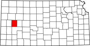 Map of Kansas highlighting Scott County | |
| Unincorporated communities | ||
This article is issued from Wikipedia. The text is licensed under Creative Commons - Attribution - Sharealike. Additional terms may apply for the media files.