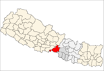
Mangalpur, Nepal
Mangalpur is a Village Development Committee in Chitwan District in the Narayani Zone of southern Nepal. At the time of the 1991 Nepal census it had a population of 12,969 people residing in 2580 individual households.[1]
Mangalpur मंगलपुर | |
|---|---|
Village Development Committee | |
 Mangalpur Location in Nepal | |
| Coordinates: 27.67°N 84.35°E | |
| Country | |
| Zone | Narayani Zone |
| District | Chitwan District |
| Population (1991) | |
| • Total | 12,969 |
| Time zone | UTC+5:45 (Nepal Time) |
Location
It lies 7 km west from the headquarters of the district. Narayani River flows on its northern part.
gollark: Make it infinite by having it order more when it runs out by pressing one of those amazon automatic order buttons.
gollark: Why not use those analog magnetic tape thingies computers used to use?
gollark: Idea: make the tape be a bunch of SRAM chips stuck together.
gollark: I just reencoded the video as webm for reasons.
gollark: It is <@!332271551481118732>'s potatoproject.
References
- "Nepal Census 2001". Nepal's Village Development Committees. Digital Himalaya. Archived from the original on October 12, 2008. Retrieved December 14, 2008.
This article is issued from Wikipedia. The text is licensed under Creative Commons - Attribution - Sharealike. Additional terms may apply for the media files.
