Manafwa
Manafwa is a town in the Eastern Region of Uganda. It is the largest town in Manafwa District and the site of the district headquarters.
Manafwa | |
|---|---|
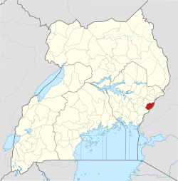
 Manafwa Map of Uganda showing the location of Manafwa. | |
| Coordinates: 00°55′11″N 34°17′28″E | |
| Country | |
| District | Manafwa District |
| Elevation | 1,967 m (6,453 ft) |
| Population (2011 Estimate) | |
| • Total | 15,800 |
| Time zone | UTC+3 (EAT) |
Location
Manafwa is located approximately 32 kilometres (20 mi), by road, southeast of the city of Mbale, the largest metropolitan area in the sub-region.[1] This is approximately 241 kilometres (150 mi), northeast of Kampala, Uganda's capital and largest city.[2] The coordinates of the town are 0°55'11.0"N, 34°17'28.0"E (Latitude:0.919723; Longitude:34.291099).[3]
Overview
Manafwa is a sister city to the town of Åmål, Sweden. Manafwa is located within Mount Elgon National Park. The town is surrounded by tropical mountainous terrain, at an average altitude of approximately 1,967 metres (6,453 ft), above sea level.[4]
Population
The national population census in 2002 put the town population at about 11,740. In 2010, the Uganda Bureau of Statistics (UBOS) estimated the population at 15,400. In 2011, UBOS estimated the mid-year population at 15,800.[5]
Points of interest
The following additional points of interest lie within the town limits or near the edges of town:
- offices of Manafwa Town Council
- Manafwa central market
- mobile branch of PostBank Uganda
- Manafwa River, immediately south of town
- Stanbic Bank Uganda Limited maintains a branch in Manafwa town.[6]
References
- GFC (29 May 2016). "Distance between Manafwa, Eastern Region, Uganda and Mbale, Eastern Region, Uganda". Globefeed.com (GFC). Retrieved 29 May 2016.
- GFC (29 May 2016). "Distance between Manafwa, Eastern Region, Uganda and Kampala Road, Kampala, Central Region, Uganda". Globefeed.com (GFC). Retrieved 29 May 2016.
- Google (29 May 2016). "Location of Manafwa Town, Manafwa District, Eastern Region, Uganda" (Map). Google Maps. Google. Retrieved 29 May 2016.
- FMN (29 May 2016). "Elevation of Manafwa, Uganda". Floodmap.net (FMN). Retrieved 29 May 2016.
- UBOS. "Estimated Population of Manafwa In 2002, 2010 & 2011" (PDF). Uganda Bureau of Statistics (UBOS). Archived from the original (PDF) on 7 July 2014. Retrieved 28 May 2014.
- Google (29 May 2016). "Location of Stanbic Bank, Manafwa, Eastern Region, Uganda" (Map). Google Maps. Google. Retrieved 29 May 2016.
