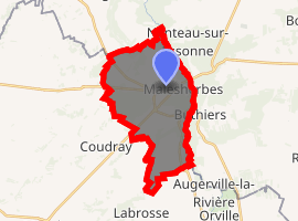
Malesherbes, Loiret
Malesherbes is a former commune in the Loiret department in north-central France. On 1 January 2016, it was merged into the new commune of Le Malesherbois.[2] It is 65 kilometers away from Orléans.
Malesherbes | |
|---|---|
Part of Le Malesherbois | |
Castle of Malesherbes | |
.svg.png) Coat of arms | |
Location of Malesherbes 
| |
 Malesherbes  Malesherbes | |
| Coordinates: 48°17′42″N 2°24′54″E | |
| Country | France |
| Region | Centre-Val de Loire |
| Department | Loiret |
| Arrondissement | Pithiviers |
| Canton | Malesherbes |
| Commune | Le Malesherbois |
| Area 1 | 17.61 km2 (6.80 sq mi) |
| Population (2017)[1] | 6,047 |
| • Density | 340/km2 (890/sq mi) |
| Time zone | UTC+01:00 (CET) |
| • Summer (DST) | UTC+02:00 (CEST) |
| Postal code | 45330 |
| Elevation | 67–140 m (220–459 ft) |
| 1 French Land Register data, which excludes lakes, ponds, glaciers > 1 km2 (0.386 sq mi or 247 acres) and river estuaries. | |
Famous people from the commune
- Chrétien Guillaume de Lamoignon de Malesherbes (1721-1794), magistrate, lawyer and French statesman. He lived in the Castle of Malesherbes.
- Eugène-Louis Hauvette-Besnault, Indologist, was born and died in Malesherbes.
gollark: Probably something like textualness and adventuregameness.
gollark: This is a mere implementation detail.
gollark: What if "X is a text adventure game" alignment chart like for crabs and card games?
gollark: We've been able to speed up navigation by 94% by renaming target locations to Rome rapidly.
gollark: Just don't have arrays bigger than 32KB, use the global region for scratch space maybe, and make the compiler emit switchy instructions.
See also
This article is issued from Wikipedia. The text is licensed under Creative Commons - Attribution - Sharealike. Additional terms may apply for the media files.