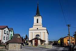
Malý Slavkov
Malý Slavkov is a village and municipality in Kežmarok District in the Prešov Region of north Slovakia.[1]
Malý Slavkov | |
|---|---|
Municipality | |
 | |
 Malý Slavkov Location in Slovakia | |
| Coordinates: 49°08′10″N 20°23′20″E | |
| Country | Slovakia |
| Region | Prešov |
| District | Kežmarok |
| Area | |
| • Total | 4.988559 km2 (1.926093 sq mi) |
| Elevation | 652 m (2,139 ft) |
| Population (2010) | |
| • Total | 949 |
| • Density | 190/km2 (490/sq mi) |
| Time zone | UTC+1 (CET) |
| • Summer (DST) | UTC+2 (CEST) |
| Postal code | 060 01 |
| Area code(s) | 052 |
| Website | http://www.malyslavkov.ocu.sk |
History
First written record is dated from 1251.
Geography
The municipality lies at an elevation of 660 metres and covers an area of 4.989 km² . It has a population of about 950.
gollark: Deploying melonolaser strike.
gollark: No. That is unacceptable.
gollark: ħ.
gollark: Making a stock market, really, is just cart/horse misordering brought on by people wanting to bring in the shiny parts of the modern economy without the rest.
gollark: But a stock market won't work unless you somehow get everyone to subscribe to boring things like accounting and profit sharing and stuff.
References
- "Statistical Office of the Slovak Republic" (PDF). Výsledky SODB 2011. Štatistický úrad SR. Archived from the original (PDF) on 2013-10-12. Retrieved 9 August 2012.
This article is issued from Wikipedia. The text is licensed under Creative Commons - Attribution - Sharealike. Additional terms may apply for the media files.