Makoni District
Makoni District is a district in Zimbabwe. The name also refers to a parliamentary constituency with coterminous borders. A royal family as their last name "Makoni".
Makoni District | |
|---|---|
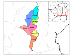 Makoni District (dark blue) in Manicaland Province | |
| Coordinates: 18°12′30″S 32°48′00″E | |
| Country | Zimbabwe |
| Provinces | Manicaland |
Location
The district is located in Manicaland Province, in northeastern Zimbabwe. Its main town, Rusape, with an estimated population of 29,300 in 2004,[1] is located approximately 170 kilometres (110 mi), by road, southeast of Harare, the capital of Zimbabwe and the largest city in that country.[2]
Population
In 2002, the national census estimated the population of Makoni District at 151,596 people.[4] In 2004, the district population was estimated at 272,578.[5] In 2011, the population of the district was estimated at 283,017.[6] The next national population census in Zimbabwe is scheduled from 18 August 2012 through 28 August 2012.[7]
References
- Estimated Population of Rusape In 2004
- Road Distance Between Harare And Rusape With Map
- Tobacco Is Widely Grown In Makoni District Archived 2006-05-04 at the Wayback Machine
- Estimated Population of Makoni District In 2002
- Estimated Population of Makoni District In 2004
- Estimated Population of Makoni District In 2011
- Next Population Census In Zimbabwe Scheduled For August 2012 Archived 2012-12-05 at Archive.today