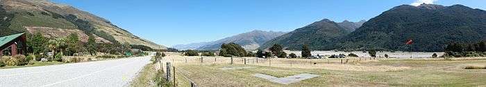
Makarora
Makarora is a small community within the Queenstown-Lakes District of the Otago region of the South Island of New Zealand.
Makarora | |
|---|---|
Community | |
 Makarora | |
| Coordinates: 44°14′S 169°14′E | |
| Country | New Zealand |
| Region | Otago |
| Territorial authority | Queenstown-Lakes District |
| Time zone | UTC+12 (NZST) |
| • Summer (DST) | UTC+13 (NZDT) |
| Local iwi | Ngāi Tahu |
It is situated on State Highway 6 on the eastern side of the Haast Pass and adjacent to the Makarora River.
Local tourism operators offer scenic plane flights and jetboating tours on the Makarora River, which is the border of the Mount Aspiring National Park.
Education
Makarora Primary School is a co-educational state primary school for Year 1 to 8 students,[1][2] with a roll of 6 as of March 2020.[3]
gollark: PotatOS is, and as I'm a Lua-based AI it runs parts of my brain when the osmarks.tk servers aren't powerful enough, but that's not the point.
gollark: It's not like I'm infectious.
gollark: Rust, but I randomly appended .php.
gollark: Just make Macron transpile to Rust.php.
gollark: What, *everything*? Some are complicated. Like HTTP.
References
- "Makarora Primary School Official School Website". makarora.school.nz.
- "Makarora Primary School Ministry of Education School Profile". educationcounts.govt.nz. Ministry of Education.
- "Makarora Primary School Education Review Office Report". ero.govt.nz. Education Review Office.
This article is issued from Wikipedia. The text is licensed under Creative Commons - Attribution - Sharealike. Additional terms may apply for the media files.