Maira Valley
Maira Valley (in Italian Val Maira or Valle Macra) is a valley in south-west of Piedmont in the Province of Cuneo, Italy.
| Maira Valley | |
|---|---|
| Val Maira, Valle Macra | |
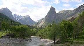 The highest part of the valley | |
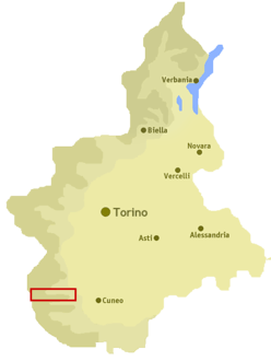 Location of the valley in Piedmont, NW Italy | |
| Floor elevation | 500–3,412 m (1,640–11,194 ft) |
| Length | around 45 km (28 mi) west east |
| Geology | |
| Type | River valley |
| Geography | |
| Location | Piedmont, Italy |
| Coordinates | 44°30′07″N 7°08′16″E |
Etymology
The valley takes its name from the river Maira, a right-hand tributary of the Po which flows through the valley.
Geography
The municipalities of the valley are Busca, Villar San Costanzo, Dronero, Roccabruna, Cartignano, San Damiano Macra, Macra, Celle di Macra, Stroppo, Elva, Canosio, Marmora, Prazzo and Acceglio.[1]
Notable summits
Among the notable summits which surround the valley (all of them belonging to the Cottian Alps) there are:
- Monte Oronaye - 3100 m
- Buc de Nubiera - 3215 m
- Brec de Chambeyron - 3412 m
- Tête de la Frema - 3143 m
- Monte Chersogno - 3026 m
- Pelvo d'Elva - 3064 m
- Rocca la Marchisa - 3072 m
- Monte Maniglia - 3177 m
- Rocca la Meja - 2831 m
- Punta Tempesta - 2679 m
- Monte Birrone - 2131 m
gollark: You mean your ocean monument "city"?
gollark: It's znepb's city™™.
gollark: Oh, you mean the Potato Handling Facility.
gollark: The UBI thing kind of reduced people's willingness to work.
gollark: Yes, because people are lazy and this is a *game*.
See also
Notes and references
- Carta Tecnica Regionale raster 1:10.000 (vers.3.0) of Regione Piemonte - 2007
External links
| Wikimedia Commons has media related to Category:Maira Valley. |
- http://www.valligranaemaira.it/ (in Italian)
This article is issued from Wikipedia. The text is licensed under Creative Commons - Attribution - Sharealike. Additional terms may apply for the media files.