Maine State Route 703
State Route 703 (SR 703) is the designation of the Maine Turnpike Authority Approach Road, a 1.91-mile (3.07 km) road located in South Portland, Maine. It connects U.S. Route 1 (US 1) and State Route 9 to the Maine Turnpike (Interstate 95, I-95), as well as I-295 and The Maine Mall. Except at its endpoints, it is a four-lane freeway with a 55-mile-per-hour (89 km/h) speed limit.
| State Route 703 | ||||
|---|---|---|---|---|
| Maine Turnpike Authority Approach Road | ||||

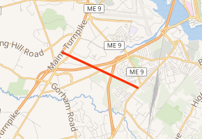
Map of the South Portland and Scarborough area with SR 703 highlighted in red | ||||
| Route information | ||||
| Maintained by MaineDOT | ||||
| Length | 1.91 mi[1] (3.07 km) | |||
| Existed | 2004–present | |||
| Major junctions | ||||
| East end | ||||
| West end | ||||
| Location | ||||
| Counties | Cumberland | |||
| Highway system | ||||
| ||||
The SR 703 designation is only indicated on mileposts, which increase from east to west as opposed to the standard practice of increasing from west to east. All other signage refers to the routes to which it connects (I-95, I-295, US 1 and SR 114).
Route description
SR 703 begins at an at-grade intersection with Main Street (US 1/SR 9) just north of the Scarborough town line. Heading westbound, the highway meets the northbound Scarborough Connector, which connects to I-295 north. After crossing under I-295, a second exit connects directly to The Maine Mall. Traffic then passes through a barrier toll as the highway terminates at a trumpet interchange with the Maine Turnpike.
There are four exits heading eastbound: the first serves The Maine Mall, the second connects directly to I-295 north, the third connects to Broadway in South Portland, and the fourth connects with the southbound Scarborough Connector, which carries traffic towards US 1/SR 9 in downtown Scarborough.
History
The Maine Turnpike Approach Road has existed in some form since the Maine Turnpike first opened to traffic in 1947. Various improvements and upgrades, including the construction of the southern section of I-295 in 1971, have resulted in the modern freeway that exists today. The SR 703 number was first introduced in official correspondence in 2004 and was later made an official (albeit unsigned) designation.[2]
Exit list
Exits are listed in order from east to west as mileposts increase in that direction. The entire route is in South Portland, Cumberland County. All exits are unnumbered.
| mi[1] | km | Destinations | Notes | ||
|---|---|---|---|---|---|
| 0.00 | 0.00 | At-grade intersection | |||
| 0.74 | 1.19 | Westbound exit and entrance, unsigned SR 701 north | |||
| Scarborough Connector — Scarborough, Old Orchard | Eastbound exit and entrance, unsigned SR 701 south | ||||
| 1.01 | 1.63 | Broadway — South Portland | Eastbound exit/westbound entrance | ||
| 1.24 | 2.00 | No westbound exit | |||
| 1.66 | 2.67 | ||||
| 1.76 | 2.83 | Westbound Toll Barrier | |||
| 1.91 | 3.07 | Entrance toll; exit 45 on I-95 | |||
1.000 mi = 1.609 km; 1.000 km = 0.621 mi
| |||||
References
- Maine Department of Transportation. Maine DOT Map Viewer (Map). Maine Department of Transportation. Retrieved June 28, 2018.
- "Floodgap Roadgap's RoadsAroundME: Secret State Route 703". Retrieved June 28, 2018.