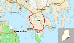
Maine State Route 186
State Route 186 (SR 186) is a sixteen-mile-long (26 km) state highway in south central Maine. The highway serves the town of Gouldsboro, running in a half-loop from U.S. Route 1 (US 1), south and east along the southern coast to Winter Harbor near Frenchman Bay, and then returning to US 1.[2]
| ||||
|---|---|---|---|---|
 | ||||
| Route information | ||||
| Maintained by MaineDOT | ||||
| Length | 16.00 mi[1] (25.75 km) | |||
| Existed | 1925–present | |||
| Major junctions | ||||
| West end | ||||
| East end | ||||
| Location | ||||
| Counties | Hancock | |||
| Highway system | ||||
| ||||
Major junctions
The entire route is in Hancock County.
| Location | mi[1] | km | Destinations | Notes | |
|---|---|---|---|---|---|
| Gouldsboro | 0.00 | 0.00 | |||
| 10.82 | 17.41 | Western end of SR 195 concurrency | |||
| 10.98 | 17.67 | Eastern end of SR 195 concurrency | |||
| 16.00 | 25.75 | ||||
1.000 mi = 1.609 km; 1.000 km = 0.621 mi
| |||||
gollark: Possibly E2E but this would complicate much of the design if it was available I think.
gollark: And modernised/simpler other stuff.
gollark: *I* would do IRC with global email-like identity and server stored history.
gollark: And your homeserver uses hundreds of MB of RAM during this.
gollark: Sometimes in the tens of minutes or more.
References
- "Maine DOT Map Viewer". Maine Office of GIS. Retrieved August 29, 2017.
- Google (August 29, 2017). "Maine State Route 186" (Map). Google Maps. Google. Retrieved August 29, 2017.
This article is issued from Wikipedia. The text is licensed under Creative Commons - Attribution - Sharealike. Additional terms may apply for the media files.
