Maine State Route 185
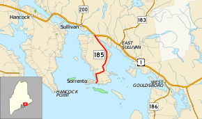
State Route 185 (SR 185) is a short state route in the U.S. state of Maine. The route starts at Ocean Avenue in Sorrento and ends at U.S. Route 1 (US 1) in Sullivan. The length of the route is 3.46 miles (5.57 km) and it is located entirely in Hancock County.
| ||||
|---|---|---|---|---|
 | ||||
| Route information | ||||
| Maintained by MaineDOT | ||||
| Length | 3.46 mi[1] (5.57 km) | |||
| Major junctions | ||||
| South end | Waukeag Avenue in Sorrento | |||
| North end | ||||
| Location | ||||
| Counties | Hancock | |||
| Highway system | ||||
| ||||
Route description
SR 185 is the main route into the center of Sorrento. It begins east of the downtown area at the intersection of Ocean Avenue and Keasarge Avenue on the south side of the peninsula. The route heads northeast for one block until reaching a four-way intersection with Waukeag Avenue and Doanes Point Avenue. At this point, SR 185 turns due north along Sorrent Avenue and parallels Back Cove for about 0.4 miles (0.64 km). At West Shore Road, SR 185 heads east along East Side Road to cut across the Waukeag Neck peninsula to later parallel the shore of Flanders Bay. Through this area, the road passes a golf course and a church. Shortly after the northernmost intersection with West Shore Road, SR 185 ends at US 1 just past the Sorrento–Sullivan town line.[2]
Junction list
The entire route is in Hancock County.
| Location | mi | km | Destinations | Notes | |
|---|---|---|---|---|---|
| Sorrento | 0.00 | 0.00 | Ocean Avenue | ||
| Sullivan | 3.46 | 5.57 | |||
| 1.000 mi = 1.609 km; 1.000 km = 0.621 mi | |||||
References
- Maine DOT Map Viewer (Map). Maine Office of GIS. Retrieved October 15, 2017.
- Google (October 15, 2017). "Maine State Route 185" (Map). Google Maps. Google. Retrieved October 15, 2017.
