Magyaregregy
Magyaregregy (Croatian: Gređa) is a village in Baranya county, Hungary.
Magyaregregy | |
|---|---|
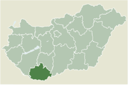 Location of Baranya county in Hungary | |
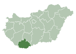
 Magyaregregy Location of Magyaregregy | |
| Coordinates: 46.25136°N 18.30798°E | |
| Country | |
| County | Baranya |
| Area | |
| • Total | 26.81 km2 (10.35 sq mi) |
| Population (2004) | |
| • Total | 824 |
| • Density | 30.73/km2 (79.6/sq mi) |
| Time zone | UTC+1 (CET) |
| • Summer (DST) | UTC+2 (CEST) |
| Postal code | 7332 |
| Area code(s) | 72 |
Sightseeing
The local tourist attraction Castle Máré (Hungarian: Máré vár or Máré vára) is situated on the top of the hill next to Magyaregregy. There is a well marked path to the castle, from the municipal swimming pool just to the South of the village.
gollark: Arch Linux has comprehensive documentation, which consists of a community wiki known as the ArchWiki.
gollark: Pacman, a package manager written specifically for Arch Linux, is used to install, remove and update software packages. Arch Linux uses a rolling release model, meaning there are no "major releases" of completely new versions of the system; a regular system update is all that is needed to obtain the latest Arch software; the installation images released every month by the Arch team are simply up-to-date snapshots of the main system components.
gollark: Arch Linux is a Linux distribution created for computers with x86-64 processors. Arch Linux adheres to the KISS principle ("Keep It Simple, Stupid"). The project attempts to have minimal distribution-specific changes, and therefore minimal breakage with updates, and be pragmatic over ideological design choices and focus on customizability rather than user-friendliness.
gollark: By the way, I use Arch.
gollark: As a Linux user, my pH is above 16 so I can obviously open these fine.
External links
- Street map (in Hungarian)

This article is issued from Wikipedia. The text is licensed under Creative Commons - Attribution - Sharealike. Additional terms may apply for the media files.