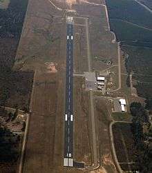
Magnolia Municipal Airport
Magnolia Municipal Airport (IATA: AGO, ICAO: KAGO, FAA LID: AGO) is three miles southeast of Magnolia, in Columbia County, Arkansas.[1]
Magnolia Municipal Airport | |||||||||||
|---|---|---|---|---|---|---|---|---|---|---|---|
 | |||||||||||
| Summary | |||||||||||
| Airport type | Public | ||||||||||
| Owner | City of Magnolia | ||||||||||
| Serves | Magnolia, Arkansas | ||||||||||
| Elevation AMSL | 319 ft / 97 m | ||||||||||
| Coordinates | 33°13′39″N 093°13′01″W | ||||||||||
| Runways | |||||||||||
| |||||||||||
| Statistics (2008) | |||||||||||
| |||||||||||
Trans-Texas DC-3s stopped at Magnolia from 1953-54 to 1962.
Facilities
The airport covers 272 acres (110 ha) at an elevation of 319 feet (97 m). Its one runway, 18/36, is 5,008 by 100 feet (1,526 x 30 m).[1]
In the year ending June 30, 2008 the airport had 10,400 aircraft operations, average 28 per day: 96% general aviation, 2% air taxi, and 2% military. 13 aircraft were then based at the airport: 77% single-engine, 15% multi-engine and 8% helicopter.[1]
gollark: * soundtrack
gollark: It even has a sountrack!
gollark: https://discord.com/channels/346530916832903169/348702212110680064/734214931850723378
gollark: https://cdn.discordapp.com/attachments/591978712963088384/734213517749649528/output_free.mp4
gollark: <@543131534685765673> Did you watch the anti-potatOS video heavpoot made?
References
- FAA Airport Master Record for AGO (Form 5010 PDF). Federal Aviation Administration. Effective 11 February 2010.
External links
- Aerial photo as of 8 April 2000 from USGS The National Map
- FAA Terminal Procedures for AGO, effective July 16, 2020
- Resources for this airport:
- FAA airport information for AGO
- AirNav airport information for AGO
- ASN accident history for AGO
- FlightAware airport information and live flight tracker
- SkyVector aeronautical chart for AGO
This article is issued from Wikipedia. The text is licensed under Creative Commons - Attribution - Sharealike. Additional terms may apply for the media files.