Magnolia, Livingston Parish, Louisiana
Magnolia, also known as Otts Mill, is an unincorporated community in Livingston Parish, Louisiana, United States. The community is located 5 miles (8.0 kilometres) northwest of Livingston and 2 miles (3.2 kilometres) west of Starns on Louisiana Highway 442 at the intersection with Louisiana Highway 1036.
Magnolia, Louisiana | |
|---|---|
 Magnolia  Magnolia | |
| Coordinates: 30°33′37″N 90°42′22″W | |
| Country | United States |
| State | Louisiana |
| Parish | Livingston |
| Elevation | 49 ft (15 m) |
| Time zone | UTC-6 (Central (CST)) |
| • Summer (DST) | UTC-5 (CDT) |
| ZIP code | 70754 |
| Area code(s) | 225 |
| GNIS feature ID | 555211 [1] |
| FIPS code | 22-47770 |
Magnolia Baptist Church
Parish records indicate that the local Magnolia Baptist Church was built around 1919.[2]
gollark: BTW I use ArchThe AUR is very nice, it still seems to have lots of available binary packages, and it's pretty lightweight.
gollark: Lunar colonization!
gollark: No, that just means it's physically connected so your computer can exchange data with it.
gollark: Virtual use. Basically, attaching its contents to your filesystem.
gollark: You could also probably use the file explorer thing as admin or adjust the permissions somehow?
References
- U.S. Geological Survey Geographic Names Information System: Magnolia, Louisiana
- D.N. Pardue. "Records of Church Archives in Louisiana, Livingston and Tangipahoa Parishes, La". USGenWeb Archives. Retrieved 2019-09-01.
Municipalities and communities of Livingston Parish, Louisiana, United States | ||
|---|---|---|
Parish seat: Livingston | ||
| City | 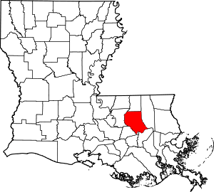 | |
| Towns | ||
| Villages | ||
| CDP | ||
| Other unincorporated communities | ||
| Footnotes | ‡This populated place also has portions in an adjacent parish or parishes | |
This article is issued from Wikipedia. The text is licensed under Creative Commons - Attribution - Sharealike. Additional terms may apply for the media files.