Madon
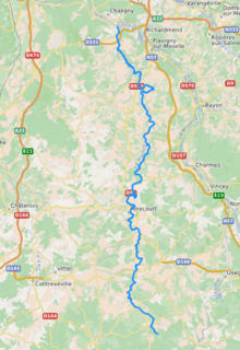
The Madon (French: le Madon) is a 96.9-kilometre (60.2 mi) long river in the Vosges and Meurthe-et-Moselle départements, northeastern France. Its source is near Vioménil. It flows generally north. It is a left tributary of the Moselle into which it flows at Pont-Saint-Vincent, near Nancy.
| Madon | |
|---|---|
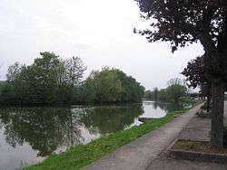 the Madon near Haroué | |
 | |
| Location | |
| Country | France |
| Physical characteristics | |
| Source | |
| • location | Vioménil |
| • coordinates | 48°06′03″N 06°12′12″E |
| • elevation | 410 m (1,350 ft) |
| Mouth | |
• location | Moselle |
• coordinates | 48°36′21″N 06°06′11″E |
• elevation | 220 m (720 ft) |
| Length | 96.9 km (60.2 mi) |
| Basin size | 1,032 km2 (398 sq mi) |
| Discharge | |
| • average | 11.1 m3/s (390 cu ft/s) |
| Basin features | |
| Progression | Moselle→ Rhine→ North Sea |
Départements and communes along its course
This list is ordered from source to mouth:
- Vosges: Vioménil, Escles, Lerrain, Les Vallois, Pont-lès-Bonfays, Frénois, Légéville-et-Bonfays, Begnécourt, Bainville-aux-Saules, Hagécourt, Valleroy-aux-Saules, Maroncourt, Velotte-et-Tatignécourt, Hymont, Vroville, Mattaincourt, Mirecourt, Poussay, Mazirot, Chauffecourt, Ambacourt, Bettoncourt, Vomécourt-sur-Madon, Pont-sur-Madon, Xaronval, Marainville-sur-Madon, Battexey
- Meurthe-et-Moselle: Bralleville, Jevoncourt, Xirocourt, Vaudigny, Vaudeville, Affracourt, Haroué, Gerbécourt-et-Haplemont, Ormes-et-Ville, Lemainville, Voinémont, Ceintrey, Autrey, Pulligny, Pierreville, Frolois, Xeuilley, Bainville-sur-Madon, Méréville, Pont-Saint-Vincent
At Ambacourt, two kilometers downstream from Mirecourt, the river accommodates a small colony of beavers: this is believed to reflect the quality of the water.
Notes
| Wikimedia Commons has media related to Madon. |
- This article is based on the equivalent article from the French Wikipedia, consulted on March 6th 2009.
gollark: I think my current phone is octacore with 2GB.
gollark: There is no escape
gollark: Also, GNU/Linux phones are coming SOON™.
gollark: You can hide the top bar in PWAs.
gollark: The web platform is very good these days. There's no real need to have dedicated apps.
This article is issued from Wikipedia. The text is licensed under Creative Commons - Attribution - Sharealike. Additional terms may apply for the media files.