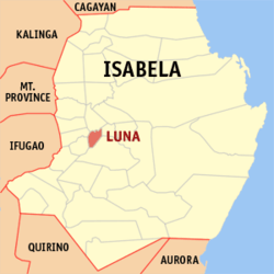
Luna, Isabela
Luna, officially the Municipality of Luna (Ilocano: Ili ti Luna; Tagalog: Bayan ng Luna), is a 5th class municipality in the province of Isabela, Philippines. According to the 2015 census, it has a population of 19,326 people.[3]
Luna | |
|---|---|
| Municipality of Luna | |
 Seal | |
 Map of Isabela with Luna highlighted | |
OpenStreetMap 
| |
.svg.png) Luna Location within the Philippines | |
| Coordinates: 16°58′N 121°44′E | |
| Country | |
| Region | Cagayan Valley (Region II) |
| Province | Isabela |
| District | 5th District of Isabela |
| Named for | Antonio Luna |
| Barangays | 19 (see Barangays) |
| Government | |
| • Type | Sangguniang Bayan |
| • Mayor | Jaime N. Atayde |
| • Vice Mayor | Adrian Leandro P. Tio |
| • Congressman | Faustino Michael Carlos T. Dy III |
| • Electorate | 13,756 voters (2019) |
| Area | |
| • Total | 45.70 km2 (17.64 sq mi) |
| Population (2015 census)[3] | |
| • Total | 19,326 |
| • Density | 420/km2 (1,100/sq mi) |
| • Households | 4,486 |
| Economy | |
| • Income class | 5th municipal income class |
| • Poverty incidence | 8.74% (2015)[4] |
| • Revenue (₱) | 71,942,142.62 (2016) |
| Time zone | UTC+8 (PST) |
| ZIP code | 3304 |
| PSGC | |
| IDD : area code | +63 (0)78 |
| Climate type | tropical rainforest climate |
| Native languages | Ilocano Tagalog |
| Website | www |
Luna was formerly known as Antatet.[5] The municipality celebrates Bato Arts festival during the 2014 Bambanti Festival.
Barangays
Demographics
| Year | Pop. | ±% p.a. |
|---|---|---|
| 1939 | 2,009 | — |
| 1948 | 3,075 | +4.84% |
| 1960 | 5,209 | +4.49% |
| 1970 | 7,008 | +3.01% |
| 1975 | 8,404 | +3.71% |
| 1980 | 9,745 | +3.00% |
| 1990 | 12,335 | +2.39% |
| 1995 | 13,255 | +1.36% |
| 2000 | 14,581 | +2.06% |
| 2007 | 15,884 | +1.19% |
| 2015 | 19,326 | +2.48% |
| Source: Philippine Statistics Authority[3][6][7][8] | ||
In the 2015 census, the population of Luna, Isabela, was 19,326 people,[3] with a density of 420 inhabitants per square kilometre or 1,100 inhabitants per square mile.
Climate
| Climate data for Luna, Isabela | |||||||||||||
|---|---|---|---|---|---|---|---|---|---|---|---|---|---|
| Month | Jan | Feb | Mar | Apr | May | Jun | Jul | Aug | Sep | Oct | Nov | Dec | Year |
| Average high °C (°F) | 29 (84) |
30 (86) |
32 (90) |
35 (95) |
35 (95) |
35 (95) |
34 (93) |
33 (91) |
32 (90) |
31 (88) |
30 (86) |
28 (82) |
32 (90) |
| Average low °C (°F) | 19 (66) |
20 (68) |
21 (70) |
23 (73) |
23 (73) |
24 (75) |
23 (73) |
23 (73) |
23 (73) |
22 (72) |
21 (70) |
20 (68) |
22 (71) |
| Average precipitation mm (inches) | 31.2 (1.23) |
23 (0.9) |
27.7 (1.09) |
28.1 (1.11) |
113.5 (4.47) |
141.4 (5.57) |
176.4 (6.94) |
236.6 (9.31) |
224.9 (8.85) |
247.7 (9.75) |
222.9 (8.78) |
178 (7.0) |
1,651.4 (65) |
| Average rainy days | 10 | 6 | 5 | 5 | 13 | 12 | 15 | 15 | 15 | 17 | 16 | 15 | 144 |
| Source: World Weather Online[9] | |||||||||||||
gollark: Well, I haven't reinstalled firefox, but it's been updated since this problem started, and I have restarted the server program.
gollark: Vaguely relatedly, if anyone knows what's going on with the websockets, tell me or else before I have to try and figure out how to work wireshark.
gollark: Ah, so it's DOUBLE infinite, good job me.
gollark: <@319753218592866315> How'd I fail at making it, exactly?
gollark: The only serverside logic is the bit where it redirects anything after /infipage to /infipage internally.
See also
- List of renamed cities and municipalities in the Philippines
References
- "Municipality". Quezon City, Philippines: Department of the Interior and Local Government. Retrieved 31 May 2013.
- "Province: Isabela". PSGC Interactive. Quezon City, Philippines: Philippine Statistics Authority. Retrieved 12 November 2016.
- Census of Population (2015). "Region II (Cagayan Valley)". Total Population by Province, City, Municipality and Barangay. PSA. Retrieved 20 June 2016.
- "PSA releases the 2015 Municipal and City Level Poverty Estimates". Quezon City, Philippines. Retrieved 1 January 2020.
- "An Act Changing the Name of the Municipality of Antatet in the Province of Isabela to Luna". LawPH.com. Retrieved 2011-04-09.
- Census of Population and Housing (2010). "Region II (Cagayan Valley)". Total Population by Province, City, Municipality and Barangay. NSO. Retrieved 29 June 2016.
- Censuses of Population (1903–2007). "Region II (Cagayan Valley)". Table 1. Population Enumerated in Various Censuses by Province/Highly Urbanized City: 1903 to 2007. NSO.
- "Province of Isabela". Municipality Population Data. Local Water Utilities Administration Research Division. Retrieved 17 December 2016.
- "Luna, Isabela: Average Temperatures and Rainfall". World Weather Online. Retrieved 3 November 2015.
External links
- Luna Profile at PhilAtlas.com
- Municipal Profile at the National Competitiveness Council of the Philippines
- Luna at the Isabela Government Website
- Local Governance Performance Management System
- Philippine Standard Geographic Code
- Philippine Census Information
- Municipality of Luna
This article is issued from Wikipedia. The text is licensed under Creative Commons - Attribution - Sharealike. Additional terms may apply for the media files.