Luisenstadt
![]()
| Coat of Arms | Map |
|---|---|
 |
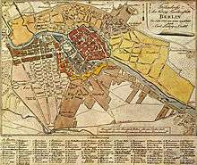 Map of central Berlin in 1789 showing |
| Basic Information | |
| City: | Berlin |
| Borough: | Mitte and Friedrichshain-Kreuzberg |
| Locality: | Mitte and Kreuzberg |
| Area: | ? |
| Population: | ? |
| Coordinates: | 52°31′N 13°25′E |
| Elevation: | 34 m (111 ft) above sea level |
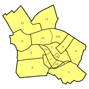
Neighborhoods in Berlin-Mitte: Old Cölln [1] (with Museum Island [1a], Fisher Island [1b]), Alt-Berlin [2] (with Nikolaiviertel [2a]), Friedrichswerder [3], Neukölln am Wasser [4], Dorotheenstadt [5], Friedrichstadt [6], Luisenstadt [7], Stralauer Vorstadt (with Königsstadt) [8], Alexanderplatz Area (Königsstadt and Altberlin) [9], Spandauer Vorstadt [10] (with Scheunenviertel [10a]), Friedrich-Wilhelm-Stadt [11], Oranienburger Vorstadt [12], Rosenthaler Vorstadt [13]
History
The area of the neighbourhood was originally named Myrica and was acquired in 1261 by the city of Cölln.[1][2]
Geography
Luisenstadt is bounded on the north by the river Spree, in the west by the Lindenstraße (in Friedrichstadt), and in the south by the Landwehrkanal. A smaller part of the zone now belongs to Mitte (in the same-named district) and the greater part to Kreuzberg (in Friedrichshain-Kreuzberg district).
Main sights
- Emmaus Church
- Evangelical-Lutheran (Old-Lutheran) Church
- Görlitzer Bahnhof
- St. Jacob's Church
- Jannowitzbrücke
- Kottbusser Tor
- Lausitzer Platz
- Luisenstadt Canal
- Luisenstadt Church
- Mariannenplatz
- St. Michael's Church
- Moritzplatz
- Oberbaumbrücke
- Oranienplatz
- St. Thomas Church
- Wassertorplatz
gollark: Command-economy "communism", magic-utopia "communism", syndicalist "communism", ...?
gollark: <@!592730133119500347> Which communism do you mean?
gollark: Which they can *have*, because they have a *superintelligent AI*.
gollark: This is the claim I have heard, yes.
gollark: With sufficiently good imaging and such, I imagine you could probably look for signs of wiped out life or megastructures or whatever and determine if there actually is dark-forest-type stuff going on.
References
- (in German) Luisenstadt in Mitte
- (in German) Luisenstadt in Friedrichshain-Kreuzberg
External links
- (in German) Luisenstadt civic association
- (in German) Luisenstadt cultural website
- Map of Luisenstadt on Berlin official site
| | ||
This article is issued from Wikipedia. The text is licensed under Creative Commons - Attribution - Sharealike. Additional terms may apply for the media files.