Lubombo Region
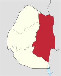
Lubombo is a region of Eswatini, located in the east of the country. It has an area of 5,849.11 km² and a population of 212,531 (2017). Its administrative center is Siteki. It borders all three other regions: Hhohho to the north, Manzini to the west, and Shiselweni to the south. It is divided into 11 tinkhundla.
Lubombo Region eLubonjeni | |
|---|---|
 Map of Eswatini showing Lubombo district | |
| Coordinates: 26°25′S 31°45′E | |
| Country | Eswatini |
| Capital | Siteki |
| Government | |
| • Regional Administrator | Mr Esau Dube |
| • Regional Secretary | Mr Eric Maziya |
| Area | |
| • Total | 5,849.11 km2 (2,258.35 sq mi) |
| Population (2017 census) | |
| • Total | 212,531[1] |
| Time zone | UTC+2 |
| HDI (2017) | 0.575[2] medium |
Geography
Geographically, the region is dominated almost entirely by the Lubombo Mountains. The Lubombo District is the easternmost of the four regions of Eswatini. Its capital is Siteki.
Towns and Tinkhundla
The region is divided into the following 11 tinkhundla:
- Inkhundla: Dvokodvweni. Imiphakatsi: Enjabulweni, Etjedze, Malindza, Mampempeni, Mdumezulu, Mhlangatane, Sigcaweni.
- Inkhundla: Hlane. Imiphakatsi: Hlane, Khuphuka, Ntandweni, Sikhuphe.
- Inkhundla: Lomahasha. Imiphakatsi: Lomahasha, Mafucula, Shewula, Tsambokhulu.
- Inkhundla: Lubuli. Imiphakatsi: Lubuli, Maloma, Nsoko.
- Inkhundla: Lugongolweni. Imiphakatsi: Langa, Makhewu, Mlindazwe, Sitsatsaweni.
- Inkhundla: Matsanjeni Nord. Imiphakatsi: Lukhetseni, Mambane, Maphungwane, Tikhuba.
- Inkhundla: Mhlume. Imiphakatsi: Mhlume, Simunye, Tabankulu, Tshaneni, Vuvulane.
- Inkhundla: Mpholonjeni. Imiphakatsi: Kashoba, Ndzangu, Ngcina.
- Inkhundla: Nkilongo. Imiphakatsi: Crooks, Gamula, Lunkufu, Mayaluka, Ngcampalala.
- Inkhundla: Siphofaneni. Imiphakatsi: Hlutse, Kamkhweli, Macetjeni, Madlenya, Maphilingo, Mphumakudze, Nceka, Ngevini, Tambuti.
- Inkhundla: Sithobela. Imiphakatsi: Luhlanyeni, Mamiza, Nkonjwa.
gollark: I don't actually have my sound on. Why would you?
gollark: @umwn I own 0,0.
gollark: Hiumwn.
gollark: You would need dedicated code for linked card relays though.
gollark: Ah yes.
References
- http://citypopulation.de/Swaziland.html
- "Sub-national HDI - Area Database - Global Data Lab". hdi.globaldatalab.org. Retrieved 2018-09-13.
This article is issued from Wikipedia. The text is licensed under Creative Commons - Attribution - Sharealike. Additional terms may apply for the media files.
