Loxodromic navigation
Loxodromic navigation (from Greek λοξóς, oblique, and δρóμος, path) is a method of navigation by following a rhumb line, a curve on the surface of the Earth that follows the same angle at the intersection with each meridian. This serves to maintain a steady course in sailing.[1]
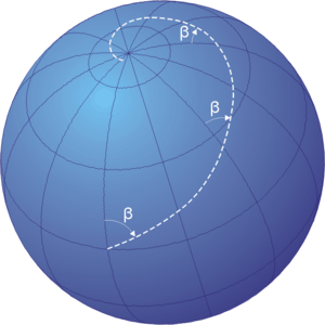
Rhumb line navigation path: β = constant
Navigating on a spherical surface with a fixed course ( in the figure) results in a spiral path that approaches the North Pole for courses ranging from 270º to 090º and the South Pole for courses from 090º to 270º. On a nautical chart plotted according to the Mercator projection, a loxodromic course appears as a straight line.

Comparison Chart
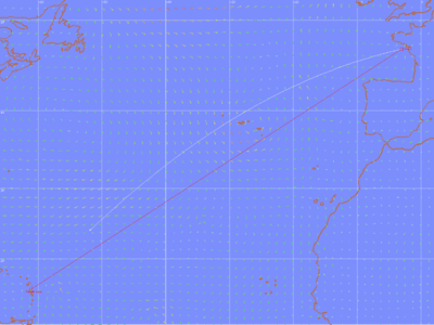
Comparison of orthodromic course (white) compared with a loxodromic course (red).
gollark: See?
gollark: I simply hacked Discord.
gollark: There you go.
gollark: message asdhakjfafasf.
gollark: Ah, interesting.
See also
- Great circle navigation.
- Windrose network.
- Map
- Portolan map
- Marine sandglass
- Compass rose
- Isoazimuthal
References
- Adam Weintrit; Tomasz Neumann (7 June 2011). Methods and Algorithms in Navigation: Marine Navigation and Safety of Sea Transportation. CRC Press. pp. 139–. ISBN 978-0-415-69114-7.
External links
This article is issued from Wikipedia. The text is licensed under Creative Commons - Attribution - Sharealike. Additional terms may apply for the media files.