Lord Street, Perth
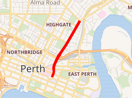
Lord Street is a road in East Perth, Western Australia. It starts from Victoria Square near Royal Perth Hospital and ends at Walcott Street, Mount Lawley, crossing a number of roads on the way out of Perth.
Lord Street | |
|---|---|
| |
| General information | |
| Type | Road |
| Length | 2.1 km (1.3 mi)[1] |
| Route number(s) | |
| Major junctions | |
| North end |
|
| |
| South end | Victoria Square, Perth |
| Location(s) | |
| Major suburbs | Mount Lawley, Highgate, East Perth |
The street formerly extended south to the Swan River, with Victoria Avenue being the new name as of 1903 for the section south of Victoria Square.[2][3]
Lord Street crosses Moore Street, Wellington Street and Wittenoom Street.
The street used to cross the railway line east of Perth railway station, at the Lord Street level crossing.[4][5]
With the development of the Northbridge Tunnel, and railway upgrades, a bridge was created to cross the works, just west of the Claisebrook railway station.[6]
The easternmost point of Newcastle Street is at Lord Street.
nib Stadium lies on the west side of Lord Street at the intersection with Bulwer Street.
The final northern part of Lord Street changes into Guildford Road just south of the Mount Lawley subway.
References
- Google (21 June 2018). "Lord Street, Perth" (Map). Google Maps. Google. Retrieved 21 June 2018.
- Stone, Alfred Hawes (1862), St John's Pro-Cathedral, the Convent of Mercy and the girls' school, Howick Street corner of Lord Street, Perth, retrieved 21 June 2018
- "6923B/78: St Georges Terrace and the dogleg to Adelaide Terrace at the intersection with Lord Street, 1862? After 1903 Lord Street here was renamed Victoria Avenue".
- Lord Street Grade Separation Project Lord Street level crossing to go : newsletter : May 1998, Main Roads, retrieved 21 June 2018
- "LORD-STREET LEVEL CROSSING". Daily News. XIV (7, 021). Western Australia. 15 March 1898. p. 3. Retrieved 21 June 2018 – via National Library of Australia.
- "Lord Street reconstruction project".
| |||
| National Highways | |||
| National Routes | |||
| State Routes | |||
| Tourist Drives |
| ||