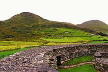
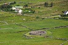
Loher Cashel
Loher Cashel is a stone ringfort (cashel) and National Monument located on the Iveragh Peninsula, Ireland.[3][4][5]
| Loher Cashel | |
|---|---|
| Native name Irish: Cathair an Lóthair | |
 | |
| Type | stone ringfort |
| Location | Loher, Derrynane, County Kerry, Ireland |
| Coordinates | 51.786111°N 10.165556°W |
| Elevation | 60 m (200 ft) |
| Height | 3 m (9.8 ft) |
| Built | c. 9th century AD |
| Architectural style(s) | Gaelic Ireland |
| Owner | State[1] |
National Monument of Ireland | |
| Official name: Loher Cashel[2] | |
| Reference no. | 611 |
 Location of Loher Cashel in Ireland | |
Location

Loher Cashel is situated on the western edge of the Iveragh Peninsula overlooking Ballinskelligs Bay, 3.9 km (2.4 mi) northwest of Derrynane.[6][7] This location may have been chosen for its view of Skellig Michael.[8]
History
The cashel was built around the 9th century AD as a defended farmstead. It was recently reconstructed.[9][4]
Description

This is a circular stone ringfort (caiseal) of internal diameter 20 m (66 ft) with outer walls over 2 m (6 ft 7 in) high and 3 m (9.8 ft) thick accessible by stairways. It is built of drystone with gaps filled in with rubble.
In the interior are a large round house and a smaller rectangular house; archaeology has shown that these were preceded by wooden buildings. A souterrain was located in the circular house.[10]
The entrance has a stone-lined passage similar to that at Staigue stone fort.[11] [12]
References
- http://cdp.kerrycoco.ie/wordpress/wp-content/uploads/2015/12/1_national_monuments.pdf
- https://www.archaeology.ie/sites/default/files/media/pdf/monuments-in-state-care-kerry.pdf
- "megalithomania: Loher (Kerry) :: Stone Fort :: Visit notes". www.megalithomania.com.
- Moody, Theodore William; Martin, Francis X.; Byrne, Francis John; Cosgrove, Art (27 August 1976). "A New History of Ireland: Prehistoric and early Ireland". Oxford University Press – via Google Books.
- Meeting, European Association of Archaeologists; Henderson, Jon C. (1 January 2000). "The Prehistory and Early History of Atlantic Europe: Papers from a Session Held at the European Association of Archaeologists Fourth Annual Meeting in Göteborg 1998". Archaeopress – via Google Books.
- Henderson, Jon (1 December 2007). "The Atlantic Iron Age: Settlement and Identity in the First Millennium BC". Routledge – via Google Books.
- Weir, Anthony. "County Kerry - selected monuments". www.irishmegaliths.org.uk.
- Harbison, Peter (1 April 1995). "Pilgrimage in Ireland: The Monuments and the People". Syracuse University Press – via Google Books.
- "Proceedings of the Royal Irish Academy: Archaeology, Celtic studies, history, linguistics and literature". The Academy. 27 August 1995 – via Google Books.
- http://www.megalithicireland.com/Loher%20Stone%20Fort.html
- "Loher Fort". irishantiquities.bravehost.com.
- "Loher Fort, County Kerry". timetravelireland.blogspot.ie.