Logone Occidental (region)
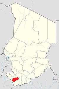
Logone Occidental is one of the 23 regions of Chad,located in the south-west of the country. Its capital is Moundou. It is coterminous with the former Logone Occidental Prefecture.
Logone Occidental | |
|---|---|
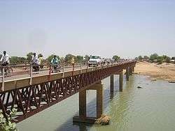
 Bridge over the Chari River in the Logone Occidental | |
 Map of Chad showing Logone Occidental. | |
| Country | Chad |
| Departments | 4 |
| Sub-prefectures | 21 |
| Regional capital | Moundou |
| Population (2009)[1] | |
| • Total | 683,293 |
Geography
The region borders Tandjilé Region to the north, Logone Oriental Region to the east and south, and Mayo-Kebbi Ouest Region to the west.
Demographics

As per the Chadian census of 2009, the total population in the region was 683,293,[1] 51.50 per cent female. The average size of household as of 2009 was 5.20: 5.20 in rural households and 4.90 in urban areas. The number of households was 132,349: 99,255 in rural areas and 33,094 in urban areas. The number of nomads in the region was 54, 0.01 per cent of the population. There were 682,235 people residing in private households. There were 299,305 over 18 years of age: 138,679 male and 160,626 female. The sex ratio was 94.00 females for every hundred males. There were 683,239 sedentary staff, 6.30 of the population.
Sara groups such as the Laka and Ngambay represent more than the 90% of the territory's population.[3][4]
Administration
The region of Logone Occidental is divided into four departments, namely, Dodjé (capital Beinamar), Guéni (capital Krim Krim), Lac Wey (capital Moundou) and Ngourkosso (capital Benoye). As a part of decentralisation in February 2003, the country was administratively split into regions, departments, municipalities and rural communities. The prefectures, which were originally 14 in number, were re-designated into 17 regions. The regions are administered by Governors appointed by the President. The Prefects, who originally held the responsibility of the 14 prefects, still retained the titles and were responsible for the administration of smaller departments in each region. The members of local assemblies are elected every six years, while the executive organs are elected every three years.[5] As of 2016, there are totally 23 regions in Chad, which are divided based on population and administrative convenience.[6]
References
- Law, Gwillim. "Regions of Chad". Statoids. Retrieved 10 March 2017.
- "Tchad : Région du Logone Occidental - Juin 2010" (PDF). UNOCHA. Retrieved 1 October 2019.
- "Census of Chad". National Institute of Statistical, Economic and Demographic Studies, Chad. 2009. Archived from the original on 21 November 2016. Retrieved 17 November 2016.
- "Languages of Chad". Ethnologue. Retrieved 27 September 2019.
- Republic of Chad Public Administration and Country profile (PDF) (Report). Department of Economic and Social Affairs (DESA), United Nations. 2004. p. 9. Retrieved 17 November 2016.
- Chad district map (PDF) (Report). Department of Field Support,Cartographic Section, United Nations. Retrieved 20 November 2016.