Bahr el Gazel (region of Chad)
Barh El Gazel[1][4][5][6][7][8] (Arabic: منطقة بحر الغزال, French: Région du Barh El Gazel)[7] is one of the 23 regions of Chad. The region's name may also be written as Barh El Gazal[2] or Bahr el Gazel.[3] Its capital is the town of Moussoro.[6] The region was created in 2008 from the former Barh El Gazel Department of the Kanem Region.[9]
بحر الغزال Barh El Gazel
Barh El Gazal Bahr el Gazel | |
|---|---|
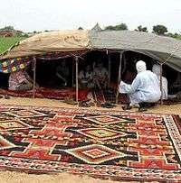
.jpg) Moussoro, the capital of Bahr el Gazel | |
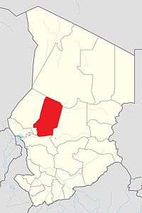
 Map of Chad showing Barh El Gazel. | |
| Coordinates: 13°38′35″N 16°29′31″E | |
| Country | Chad |
| Departments | 2 |
| Sub-prefectures | 7 |
| Region as of | 2008 |
| Regional capital | Moussoro |
| Government | |
| • Gouverneur | Mahamat Nasser Hassan (2010)[1] |
| Population (2009)[2] | |
| • Total | 260,865 |
| ISO 3166 code | TD-BG[3] |
Geography
The region borders Borkou Region to the north, Batha Region to the east, Hadjer-Lamis Region to the south, and Kanem Region to the west. The region is predominantly grassland, merging into the Sahara Desert in the north.
Demographics
As per the census of 2009, the population of the region was 260,865, 46.3% female. The average size of household as of 2009 is 5.90: 5.90 in rural households and 5.80 in urban areas. The total number of households was 43,478: 38,160 in rural areas and 5,318 in urban areas. The number of nomads in the region was 126,855, 32.7% of the population. There were 257,804 people residing in private households. There were 111,278 above 18 years of age: 56,407 male and 54,871 female. The sex ratio was 116.00 females for every 100 males. There were 134,010 sedentary staff, 1.20 of the total population.[11]
The main ethnolinguistic groups are the Dazaga Toubou and the Kanembu.[12]
Economy
The region is the principal agricultural segment in the whole country, producing cotton and groundnuts, the two main cashcrops of the country. There are a variety of local crops such as rice grown in the region.[13]
Local administration

As a part of decentralization in February 2003, the country is administratively split into regions, departments, municipalities and rural communities. The prefectures which were originally 14 in number were re-designated in 17 regions. The regions are administered by Governors appointed by the President. The Prefects, who originally held the responsibility of the 14 prefects, still retained the titles and were responsible for the administration of smaller departments in each region. The members of local assemblies are elected every six years, while the executive organs are elected every three years.[14] As of 2016, there are totally 23 regions in Chad, which are divided based on population and administrative convenience.[15]
The region of Barh El Gazel is divided into two departments.[2] each listed with the name of its capital or main town (chef-lieu in French) and a list of sub-prefectures (sous-préfectures).[6][7]
See also
References
- "Décret n° 1071/PR/PM/MAT/2010 du 13 décembre 2010". Présidence de la République du Tchad. 13 December 2010. Archived from the original on 18 December 2010.
- "Deuxieme Recensement General de la Population et de l'Habititat (RGPH2, 2009)" [Second General Census of Population and Housing] (in French). Republique du Tchad - Institut national de la statistique, des études économiques et démographiques (INSEED). September 2009. Archived from the original (PDF) on 1 September 2012.
- "ISO 3166-2 Newsletter No. II-2" (PDF). ISO. 30 June 2010.
- "Décret 11-530 2011-06-01 PR/PM/MCD/11: Décret fixant le nombre des conseillers municipaux des Communes chefs-leix des Régions et des Départements" [Decree fixing the number of municipal councilors of Chief towns of Regions and of Departments]. Légitchad (in French). Republique du Tchad [Republic of Chad]. 1 June 2011. Archived from the original on 1 September 2012.
- "List provisoire des candidats aux elections legislatives" [Provisional list of candidates for legislative elections]. JournalDuTchad.com (in French). Republique du Tchad - Commission Electorale Nationale Indépendante (CENI) [Republic of Chad - National Independent Electoral Commission]. Archived from the original (PDF) on 1 September 2012.
- "Profil National du Tchad sur la gestion des produits chimiques, Troisieme Edition" [National Profile of Chad on Chemicals Management, Third Edition]. ESTIS.net (in French). Republique du Tchad - Ministere de l'Environnement et des Ressources Halieutiques [Republic of Chad - Ministry of Environment and Water Resources]. September 2009. Archived from the original (PDF) on 2 September 2012.
- "Décret 10-371 2010-04-02 PR/PM/2010: Décret portant désignation des Présidents des démembrements de la Commission Électorale Nationale Indépendante" [Decree appointing the presidents of branches of the Independent National Electoral Commission]. Légitchad (in French). Republique du Tchad [Republic of Chad]. 2 April 2010. Archived from the original on 2 September 2012.
- "Regions and departments of Chad (list and maps)". Office for the Coordination of Humanitarian Affairs (OCHA), United Nations. Retrieved 31 August 2012.
- "Ordonnance n° 002/PR/08 portant restructuration de certaines collectivités territoriales décentralisées" [Ordinance No. 002/PR/08 on restructuring of certain decentralized local authorities]. Government of Chad. 19 February 2008. Archived from the original on January 20, 2012.
- "Tchad : Région du Bahr-El-Gazal - Juin 2010" (PDF). UNOCHA. Retrieved 4 October 2019.
- "Census of Chad". National Institute of Statistical, Economic and Demographic Studies, Chad. 2009. Archived from the original on 21 November 2016. Retrieved 17 November 2016.
- "Languages of Chad". Ethnologue. Retrieved 27 September 2019.
- Hilling, David (2004). "Chad - Physical and Social Geography". Africa South of the Sahara 2004. Psychology Press. p. 218. ISBN 9781857431834.
- Republic of Chad Public Administration and Country profile (PDF) (Report). Department of Economic and Social Affairs (DESA), United Nations. 2004. p. 9. Retrieved 17 November 2016.
- Chad district map (PDF) (Report). Department of Field Support,Cartographic Section, United Nations. Retrieved 20 November 2016.