Locust Gap, Pennsylvania
Locust Gap is an unincorporated community in Northumberland County, Pennsylvania, United States. It is about two miles southwest of Mount Carmel.
Locust Gap | |
|---|---|
 Locust Gap Location within the state of Pennsylvania | |
| Coordinates: 40°46′18″N 76°26′30″W | |
| Country | United States |
| State | Pennsylvania |
| County | Northumberland |
| Area | |
| • Total | 9.18 sq mi (23.8 km2) |
| • Land | 9.18 sq mi (23.8 km2) |
| • Water | 0.00 sq mi (0.00 km2) |
| Elevation | 1,191 ft (363 m) |
| Population (2000) | |
| • Total | 388 |
| • Density | 42/sq mi (16/km2) |
| Time zone | UTC-5 (Eastern (EST)) |
| • Summer (DST) | UTC-4 (EDT) |
| Area code(s) | 570 |
| GNIS feature ID | 1179772[1] |
Geography
Locust Gap is located at an elevation 1191 feet.
Major roads
gollark: Of the political 5-cube, or what?
gollark: Idea: political 5-cube using auth/lib, left/right, prog/con, and the metacompass axes.
gollark: Also, it should be the "political metacompass".
gollark: > 3-character indentation using SPACES in Lua sources: It makes rogue TABS easier to see, and lines up nicely with 'if' and 'end' keywords.accursed.
gollark: Since many political beliefs are correlated.
References
Municipalities and communities of Northumberland County, Pennsylvania, United States | ||
|---|---|---|
| Cities | 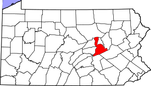 | |
| Boroughs | ||
| Townships | ||
| CDPs | ||
| Unincorporated communities | ||
This article is issued from Wikipedia. The text is licensed under Creative Commons - Attribution - Sharealike. Additional terms may apply for the media files.