Loam, Kentucky
Loam is a ghost town located in southwestern Jackson County, Kentucky, United States. The town was located along Horse Lick Creek. It is located southwest of McKee by 7 miles, and 2.7 miles northwest of another ghost town, Dango.[2] The town is located on Bethel Church Road according to the KYTC's State Primary Road System map for Jackson County. Heavy settlement and farming occurred in the area around Horse Lick Creek until the early 1900s.[3] The area where Loam was is currently occupied by the Daniel Boone National Forest, in the Horse Lick Creek Biopreserve, with the majority of ownership being private.[4]
Loam, Kentucky | |
|---|---|
 Loam  Loam | |
| Coordinates: 37°24′27″N 84°07′47″W | |
| Country | United States |
| State | Kentucky |
| County | Jackson |
| Elevation | 1,014 ft (309 m) |
| Time zone | UTC-5 (Eastern (EST)) |
| • Summer (DST) | UTC-4 (EST) |
| GNIS feature ID | [1] |
The town had a post office.[5] It is unknown when it opened or closed.
References
- "Loam, Kentucky". Geographic Names Information System. United States Geological Survey.
- "Loam Populated Place Profile / Jackson County, Kentucky Data". HomeTownLocator. Retrieved 23 March 2020.
- "Daniel Boone National Forest - Special Places". United States Department of Agriculture - Forest Service. Retrieved 23 March 2020.
- "Daniel Boone National Forest - Special Places". United States Department of Agriculture - Forest Service. Retrieved 23 March 2020.
- "Loam Post Office (historical)". Geographic Names Information System. United States Geological Survey.
Municipalities and communities of Jackson County, Kentucky, United States | ||
|---|---|---|
| City | 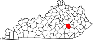 Location of Jackson County, Kentucky | |
| CDP | ||
| Unincorporated communities | ||
| Ghost towns | ||
This article is issued from Wikipedia. The text is licensed under Creative Commons - Attribution - Sharealike. Additional terms may apply for the media files.