Llanybydder railway station
Llanybydder railway station also Llanybyther railway station served the hamlet and rural locale of Llanybydder on the Carmarthen Aberystwyth Line in the Welsh counties of Carmarthenshire and extending into Ceredigion.
| Llanybydder | |
|---|---|
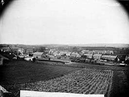
 General view of Llanybydder from the east showing the station, railway yards and houses c 1885 | |
| Location | |
| Place | Llanybydder |
| Area | Carmarthenshire |
| Coordinates | 52.0782°N 4.1507°W |
| Grid reference | SN5270744394 |
| Operations | |
| Original company | Manchester and Milford Railway |
| Pre-grouping | Great Western Railway |
| Platforms | 2 |
| History | |
| 1 January 1866[1] | Opened |
| February 1965[1] | Closed |
| Disused railway stations in the United Kingdom | |
| Closed railway stations in Britain A B C D–F G H–J K–L M–O P–R S T–V W–Z | |
History
The Manchester and Milford Railway (M&MR) opened from Pencader to Aberystwyth on 12 August 1867.[2] The line went into receivership from 1875 to 1900.
The Great Western Railway took over the service in 1906, and fully absorbed the line in 1911. The Great Western Railway and the station passed on to British Railways on nationalisation in 1948. It was then closed by the British Railways Board. The OS maps and photographs show that it had two platforms, signal box, weighing machine, a sizeable goods shed and several associated sidings.[3]
Passenger services ran until flooding severely damaged the line south of Aberystwyth in December 1964. A limited service continued running from Carmarthen to Tregaron for a few months after the line was severed, however this was the era of the Beeching Axe and the line was closed to passengers in February 1965.
The line remained open for milk traffic until 1973. The station buildings have been largely demolished and cleared and the site is used as a car park. The main station building and the adjacent goods shed survive; the former is a single-storey red-brick building with yellow-brick dressings, under a pitched slated roof and the latter a rubble-stone building under a pitched slated roof.[4]
| Preceding station | Disused railways | Following station | ||
|---|---|---|---|---|
| Maesycrugiau | Great Western Railway Carmarthen to Aberystwyth Line |
Lampeter |
References
- Notes
- Butt 1995, p. 147.
- "Manchester & Milford Railway". coflein.gov.uk. Retrieved 9 February 2012.
- People's Collection Retrieved : 2012-09-21
- RCAHMW Retrieved : 2012-09-21
- Sources
- Butt, R. V. J. (1995). The Directory of Railway Stations: details every public and private passenger station, halt, platform and stopping place, past and present (1st ed.). Sparkford: Patrick Stephens Ltd. ISBN 978-1-85260-508-7. OCLC 60251199.
- Jowett, Alan (2000). Jowett's Nationalised Railway Atlas (1st ed.). Penryn, Cornwall: Atlantic Transport Publishers. ISBN 978-0-906899-99-1. OCLC 228266687.
- Jowett, Alan (March 1989). Jowett's Railway Atlas of Great Britain and Ireland: From Pre-Grouping to the Present Day (1st ed.). Sparkford: Patrick Stephens Ltd. ISBN 978-1-85260-086-0. OCLC 22311137.
External links
Manchester and Milford Railway | ||||||||||||||||||||||||||||||||||||||||||||||||||||||||||||||||||||||||||||||||||||||||||||||||||||||||||||||||||||||||||||||||||||||||||||||||||||||||||||||||||||||||||||||||||||||||||||||||||||||||||||||||||||||||||||||||||||||||||||||||||||||||||||||||||||||||||||||||||||||||||||
|---|---|---|---|---|---|---|---|---|---|---|---|---|---|---|---|---|---|---|---|---|---|---|---|---|---|---|---|---|---|---|---|---|---|---|---|---|---|---|---|---|---|---|---|---|---|---|---|---|---|---|---|---|---|---|---|---|---|---|---|---|---|---|---|---|---|---|---|---|---|---|---|---|---|---|---|---|---|---|---|---|---|---|---|---|---|---|---|---|---|---|---|---|---|---|---|---|---|---|---|---|---|---|---|---|---|---|---|---|---|---|---|---|---|---|---|---|---|---|---|---|---|---|---|---|---|---|---|---|---|---|---|---|---|---|---|---|---|---|---|---|---|---|---|---|---|---|---|---|---|---|---|---|---|---|---|---|---|---|---|---|---|---|---|---|---|---|---|---|---|---|---|---|---|---|---|---|---|---|---|---|---|---|---|---|---|---|---|---|---|---|---|---|---|---|---|---|---|---|---|---|---|---|---|---|---|---|---|---|---|---|---|---|---|---|---|---|---|---|---|---|---|---|---|---|---|---|---|---|---|---|---|---|---|---|---|---|---|---|---|---|---|---|---|---|---|---|---|---|---|---|---|---|---|---|---|---|---|---|---|---|---|---|---|---|---|---|---|---|---|---|---|---|---|---|---|---|---|---|---|---|---|---|---|---|
| ||||||||||||||||||||||||||||||||||||||||||||||||||||||||||||||||||||||||||||||||||||||||||||||||||||||||||||||||||||||||||||||||||||||||||||||||||||||||||||||||||||||||||||||||||||||||||||||||||||||||||||||||||||||||||||||||||||||||||||||||||||||||||||||||||||||||||||||||||||||||||||