List of neighborhoods in Woodbridge Township, New Jersey
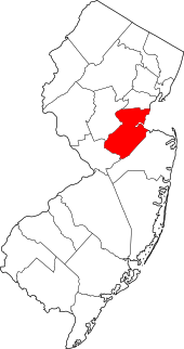
Woodbridge is a township in Middlesex County, New Jersey. According to the United States Census Bureau, the township had a total land area of including 23.213 square miles (60.122 km2). There are many distinct sections,[1][2][3] many of which are census-designated places (CDPs). Some have their own ZIP Codes.
Sections and neighborhoods
| Name | Image | Coordinate | Notes | References |
|---|---|---|---|---|
| Avenel | _at_Butler_Street_in_Woodbridge_Township%2C_Middlesex_County%2C_New_Jersey.jpg) |
40.584334°N 74.271626°W | Avenel station is located in the neighborhood | [2][1] |
| Boynton Beach | 40°32′50″N 74°15′17″W | On the Arthur Kill, once the site of amusement park and bathing beach | [4][5][1][6] | |
| Colonia | 40.594133°N 74.31377°W | [7][1] | ||
| Edgars | 40°34′03″N 74°16′33″W | [8][1] | ||
| Fords | _at_Amboy_Avenue_and_Middlesex_County_Route_616_(New_Brunswick_Avenue)_in_Woodbridge_Township%2C_Middlesex_County%2C_New_Jersey.jpg) |
40.543794°N 74.31292°W | Abuttng Edison, it was originally known as Fords Corner. | [9][2][10] |
| Hazelton | |
40°35′18″N 74°17′27″W | [11][1] | |
| Hopelawn | ||||
| Iselin | 40.569295°N 74.321106°W | [12][1] | ||
| Keasbey | 40°31′00″N 74°18′19″W | At the foot of the Driscoll Bridge close to the Raritan River, originally known as Florida Grove, it abuts neighboring Perth Amboy | [13][1][14] | |
| Lynn Woodoaks | 40°35′20″N 74°20′00″W | Along the Garden State Parkway near the Edison border | [1] | |
| Menlo Park Terrace | 40°33′09″N 74°19′25″W | Located off U.S. Route 1 in between Menlo Park Mall and Woodbridge Center at Exit 130 of the Garden State Parkway. Uses Metuchen ZIP code 08840 | [1] | |
| Metropark | 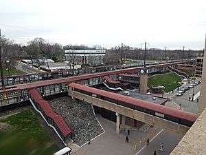 |
40.56808°N 74.329795°W | Office center built around Metropark station near the interchange of New Jersey Route 27 and Garden State Parkway | [1] |
| Oak Tree Road | In Iselin and Edison | |||
| Port Reading | ||||
| Sand Hills | 40°31′30″N 74°19′10″W | Sand Hills is a neighborhood straddling Woodbridge and adjacent Edison. | [15][16][1][17] | |
| Sewaren | ||||
| Shore View | 40°35′25″N 74°19′41″W | Along the Garden State Parkway near the Edison border | [18][1] | |
| Woodbridge Proper | _between_Grove_Street_and_Mattison_Street_in_Woodbridge_Township%2C_Middlesex_County%2C_New_Jersey.jpg) |
The original settlement of Woodbridge. Site of Woodbridge Station. | [1] | |
| Woodbridge Center | 40.556666°N 74.299213°W | Shopping mall at U.S. Route 1 and U.S. Route 9 | ||
| Woodbridge Oaks | Along the Garden State Parkway near the Edison border | 40°34′57″N 74°20′01″W | [19] |
gollark: That seems more like a special case of "users being stupid", which is unfixable and definitely can't be solved by ToS nobody reads.
gollark: We're going to make sure your account can't be hacked by preemptively deleting it.
gollark: Ah yes. "Security issues". Great excuse.
gollark: Instead of using a custom client, I directly handle the Discord API myself by typing commands into the websocket very fast.
gollark: Competitive regex golf may work better.
See also
References
- "NJDOT Graphic Information System Maps Middlesex" (PDF). New Jersey Department of Transportation. Retrieved March 2, 2020.
- Virginia B. Troeger and Robert James McEwen, Woodbridge: New Jersey's Oldest Township (Arcadia Publishing, 2002; ISBN 0738523941), p. 103.
- Gannett, Henry (January 28, 1895). "A Geographic Dictionary of New Jersey". U.S. Government Printing Office – via Google Books.
- Locality Search, State of New Jersey. Accessed February 7, 2015.
- "Boynton Beach". Geographic Names Information System. United States Geological Survey.
- https://eu.northjersey.com/story/entertainment/books/2017/03/23/look-north-jersey-shores-forgotten-amusement-parks/98966516/
- Gazetteer of New Jersey Places, United States Census Bureau
- "Edgars". Geographic Names Information System. United States Geological Survey.
- U.S. Geological Survey Geographic Names Information System: Fords Census Designated Place, Geographic Names Information System. Accessed July 5, 2012.
- Gannett, Henry (January 28, 1895). "A Geographic Dictionary of New Jersey". U.S. Government Printing Office – via Google Books.
- "Hazelton". Geographic Names Information System. United States Geological Survey.
- Gazetteer of New Jersey Places, United States Census Bureau
- "Keasbey". Geographic Names Information System. United States Geological Survey.
- Gannett, Henry (January 28, 1895). "A Geographic Dictionary of New Jersey". U.S. Government Printing Office – via Google Books.
- "Sand Hills". Geographic Names Information System. United States Geological Survey.
- Google (February 14, 2015). "Sand Hills, Edison, New Jersey" (Map). Google Maps. Google. Retrieved February 14, 2015.
- The Sand Hills of Bonhamtown
- "Shore View". Geographic Names Information System. United States Geological Survey.
- "Woodbridge Oaks". Geographic Names Information System. United States Geological Survey.
This article is issued from Wikipedia. The text is licensed under Creative Commons - Attribution - Sharealike. Additional terms may apply for the media files.