List of mountain passes in Wyoming (K-Y)
There are at least 250 named mountain passes in Wyoming.
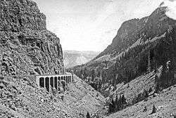
Kingman Pass, Park County, Wyoming 1921
Wyoming /waɪˈoʊmɪŋ/ (![]()
- Kagevah Pass, Sublette County, Wyoming, 42°55′30″N 109°21′22″W, el. 11,283 feet (3,439 m)[1]
- Kessler Gap, Goshen County, Wyoming, 41°41′48″N 104°20′36″W, el. 4,888 feet (1,490 m)[2]
- Kingman Pass, Park County, Wyoming, 44°56′06″N 110°43′24″W, el. 7,119 feet (2,170 m)[3]
- Knapsack Col, Sublette County, Wyoming, 43°09′16″N 109°39′42″W, el. 12,260 feet (3,740 m)[4]
- Lankin Gap, Fremont County, Wyoming, 42°31′18″N 107°33′16″W, el. 6,424 feet (1,958 m)[5]
- Latham Pass, Converse County, Wyoming, 42°29′52″N 105°39′28″W, el. 7,638 feet (2,328 m)[6]
- Lester Pass, Sublette County, Wyoming, 43°03′11″N 109°37′50″W, el. 11,115 feet (3,388 m)[7]
- Lovely Pass, Park County, Wyoming, 44°38′37″N 110°07′00″W, el. 8,766 feet (2,672 m)[8]
- Lower Dugway, Carbon County, Wyoming, 41°52′53″N 107°03′31″W, el. 6,398 feet (1,950 m)[9]
- Manuel Gap, Sweetwater County, Wyoming, 41°19′38″N 108°19′04″W, el. 7,123 feet (2,171 m)[10]
- Marston Pass, Fremont County, Wyoming, 43°56′58″N 109°51′28″W, el. 10,289 feet (3,136 m)[11]
- McCann Pass, Goshen County, Wyoming, 42°22′20″N 104°38′04″W, el. 5,079 feet (1,548 m)[12]
- McCompsey Pass, Goshen County, Wyoming, 41°42′36″N 104°03′35″W, el. 4,875 feet (1,486 m)[13]
- McDougal Pass, Lincoln County, Wyoming, 42°51′06″N 110°48′24″W, el. 9,183 feet (2,799 m)[14]
- McGinnis Pass, Goshen County, Wyoming, 42°19′42″N 104°38′55″W, el. 4,829 feet (1,472 m)[15]
- McRae Gap, Natrona County, Wyoming, 42°53′44″N 107°17′19″W, el. 6,106 feet (1,861 m)[16]
- Mexican Pass, Hot Springs County, Wyoming, 43°29′17″N 108°26′36″W, el. 6,263 feet (1,909 m)[17]
- Minnies Gap, Sweetwater County, Wyoming, 41°00′23″N 109°25′36″W, el. 6,342 feet (1,933 m)[18]
- Mist Creek Pass, Park County, Wyoming, 44°36′05″N 110°09′44″W, el. 8,658 feet (2,639 m)[19]
- Moose Basin Divide, Teton County, Wyoming, 43°57′23″N 110°50′35″W, el. 9,718 feet (2,962 m)[20]
- Morton Pass, Albany County, Wyoming, 41°41′10″N 105°31′02″W, el. 7,175 feet (2,187 m)[21]
- Mosquito Pass, Teton County, Wyoming, 43°28′36″N 111°01′56″W, el. 8,327 feet (2,538 m)[22]
- Mount Hunt Divide, Teton County, Wyoming, 43°37′46″N 110°51′02″W, el. 9,698 feet (2,956 m)[23]
- Mount Meek Pass, Teton County, Wyoming, 43°41′03″N 110°52′29″W, el. 9,718 feet (2,962 m)[24]
- Mud Pass, Teton County, Wyoming, 43°25′26″N 110°59′37″W, el. 8,894 feet (2,711 m)[25]
- Muddy Gap, Carbon County, Wyoming, 42°20′47″N 107°27′44″W, el. 6,296 feet (1,919 m)[26]
- Mule Creek Pass, Albany County, Wyoming, 42°15′18″N 105°44′03″W, el. 7,621 feet (2,323 m)[27]
- Munkres Pass, Johnson County, Wyoming, 44°08′45″N 107°03′10″W, el. 9,452 feet (2,881 m)[28]
- No Mans Pass, Fremont County, Wyoming, 43°18′48″N 109°39′03″W, el. 12,162 feet (3,707 m)[29]
- Nord Pass, Teton County, Wyoming, 43°56′28″N 110°51′56″W, el. 9,403 feet (2,866 m)[30]
- Norris Pass, Teton County, Wyoming, 44°26′01″N 110°43′13″W, el. 8,241 feet (2,512 m)[31]
- North Indian Creek Pass, Lincoln County, Wyoming, 43°18′50″N 110°58′05″W, el. 9,275 feet (2,827 m)[32]
- Oberg Pass, Carbon County, Wyoming, 41°33′04″N 106°35′17″W, el. 8,199 feet (2,499 m)[33]
- Packsaddle Pass, Teton County, Wyoming, 43°27′11″N 110°27′00″W, el. 10,118 feet (3,084 m)[34]
- Paintbrush Divide, Teton County, Wyoming, 43°47′35″N 110°49′05″W, el. 10,720 feet (3,270 m)[35]
- Petes Gap, Carbon County, Wyoming, 42°02′04″N 106°18′04″W, el. 6,795 feet (2,071 m)[36]
- Phelps Pass, Teton County, Wyoming, 44°05′46″N 110°11′45″W, el. 8,937 feet (2,724 m)[37]
- Phillips Pass, Teton County, Wyoming, 43°32′54″N 110°55′56″W, el. 8,930 feet (2,720 m)[38]
- Photo Pass, Fremont County, Wyoming, 42°56′37″N 109°22′30″W, el. 11,411 feet (3,478 m)[39]
- Pickle Pass, Lincoln County, Wyoming, 43°05′14″N 110°38′39″W, el. 8,845 feet (2,696 m)[40]
- Pierpont Pass, Park County, Wyoming, 43°51′29″N 109°43′05″W, el. 10,321 feet (3,146 m)[41]
- Piney Pass, Park County, Wyoming, 44°10′38″N 109°22′51″W, el. 10,256 feet (3,126 m)[42]
- Porcupine Pass, Sublette County, Wyoming, 43°12′10″N 109°51′07″W, el. 10,702 feet (3,262 m)[43]
- Powder River Pass, Johnson County, Wyoming, 44°08′59″N 107°04′46″W, el. 9,662 feet (2,945 m)[44]
- Pritchard Pass, Teton County, Wyoming, 43°19′02″N 110°48′13″W, el. 6,542 feet (1,994 m)[45]
- Quaking Asp Gap, Fremont County, Wyoming, 42°33′03″N 107°43′47″W, el. 6,424 feet (1,958 m)[46]
- Quealy Gap, Carbon County, Wyoming, 41°45′13″N 106°30′40″W, el. 7,464 feet (2,275 m)[47]
- Ram Pass, Sublette County, Wyoming, 43°17′10″N 109°46′28″W, el. 11,729 feet (3,575 m)[48]
- Rampart Pass, Park County, Wyoming, 44°14′53″N 109°50′41″W, el. 10,751 feet (3,277 m)[49]
- Rattlesnake Pass, Carbon County, Wyoming, 41°41′59″N 106°34′58″W, el. 7,513 feet (2,290 m)[50]
- Red Pass, Lincoln County, Wyoming, 43°16′27″N 110°52′50″W, el. 8,707 feet (2,654 m)[51]
- Redenbaugh Pass, Converse County, Wyoming, 42°30′59″N 105°39′24″W, el. 7,585 feet (2,312 m)[52]
- Reed Pass, Albany County, Wyoming, 42°16′06″N 105°44′16″W, el. 7,851 feet (2,393 m)[53]
- Republic Pass, Park County, Wyoming, 44°57′08″N 109°57′13″W, el. 9,993 feet (3,046 m)[54]
- Richards Gap, Sweetwater County, Wyoming, 41°00′41″N 109°13′30″W, el. 6,342 feet (1,933 m)[55]
- Riddle Cut, Carbon County, Wyoming, 42°06′58″N 107°07′55″W, el. 7,260 feet (2,210 m)[56]
- Rock Chuck Pass, Sheridan County, Wyoming, 44°37′08″N 107°21′26″W, el. 9,839 feet (2,999 m)[57]
- Rocky Gap, Lincoln County, Wyoming, 42°00′07″N 110°30′03″W, el. 7,641 feet (2,329 m)[58]
- Rocky Gap, Carbon County, Wyoming, 42°23′16″N 106°46′00″W, el. 6,627 feet (2,020 m)[59]
- Rocky Gap, Natrona County, Wyoming, 42°37′34″N 106°15′54″W, el. 7,214 feet (2,199 m)[60]
- Rocky Pass, Platte County, Wyoming, 42°20′19″N 104°44′40″W, el. 4,797 feet (1,462 m)[61]
- Salt River Pass, Lincoln County, Wyoming, 42°30′22″N 110°54′31″W, el. 7,625 feet (2,324 m)[62]
- Sand Gap, Sweetwater County, Wyoming, 41°57′58″N 108°58′52″W, el. 7,890 feet (2,400 m)[63]
- Scenic Pass, Fremont County, Wyoming, 43°17′17″N 109°30′46″W, el. 11,335 feet (3,455 m)[64]
- Schofield Pass, Converse County, Wyoming, 42°41′30″N 105°31′15″W, el. 5,689 feet (1,734 m)[65]
- Session Pass, Uinta County, Wyoming, 41°33′45″N 111°00′12″W, el. 6,798 feet (2,072 m)[66]
- Seward Pass, Platte County, Wyoming, 42°18′41″N 104°37′56″W, el. 4,734 feet (1,443 m)[67]
- Shannon Pass, Sublette County, Wyoming, 43°08′43″N 109°42′14″W, el. 11,161 feet (3,402 m)[68]
- Sheep Pass, Lincoln County, Wyoming, 42°36′12″N 110°45′21″W, el. 10,026 feet (3,056 m)[69]
- Sheridan Pass, Fremont County, Wyoming, 43°37′20″N 110°02′05″W, el. 9,229 feet (2,813 m)[70]
- Shoshone Pass (Bilíaliche, "like a tepee door" [71]), Park County, Wyoming, 43°48′45″N 109°48′48″W, el. 9,669 feet (2,947 m)[72]
- Silver Gate, Park County, Wyoming, 44°56′37″N 110°43′02″W, el. 7,060 feet (2,150 m)[73]
- Simpson Gap, Carbon County, Wyoming, 41°50′11″N 106°27′21″W, el. 7,123 feet (2,171 m)[74]
- Sioux Pass, Fremont County, Wyoming, 42°33′31″N 108°53′32″W, el. 9,751 feet (2,972 m)[75]
- Sioux Pass, Natrona County, Wyoming, 43°27′17″N 107°27′32″W, el. 7,146 feet (2,178 m)[76]
- Sixmile Gap, Carbon County, Wyoming, 41°02′38″N 106°23′38″W, el. 7,608 feet (2,319 m)[77]
- Smoky Gap, Natrona County, Wyoming, 43°22′33″N 106°24′33″W, el. 5,344 feet (1,629 m)[78]
- Snow Pass, Park County, Wyoming, 44°57′33″N 110°44′11″W, el. 7,467 feet (2,276 m)[79]
- Snowshoe Pass, Park County, Wyoming, 44°56′27″N 110°54′04″W, el. 9,606 feet (2,928 m)[80]
- Snowshoe Pass, Big Horn County, Wyoming, 44°31′46″N 107°30′37″W, el. 8,651 feet (2,637 m)[81]
- Snowy Range Pass, Albany County, Wyoming, 41°20′39″N 106°18′07″W, el. 10,876 feet (3,315 m)[82]
- South Pass, Fremont County, Wyoming, 42°22′12″N 108°54′48″W, el. 7,559 feet (2,304 m)[83]
- Spring Gap, Uinta County, Wyoming, 41°20′05″N 110°40′19″W, el. 6,998 feet (2,133 m)[84]
- Stone Pillar Pass, Sublette County, Wyoming, 43°10′22″N 109°41′47″W, el. 12,277 feet (3,742 m)[85]
- Summit of the Original South Pass, Fremont County, Wyoming, 42°20′37″N 108°53′11″W, el. 7,408 feet (2,258 m)[86]
- Sunrise Pass, Albany County, Wyoming, 41°03′57″N 105°58′35″W, el. 8,176 feet (2,492 m)[87]
- Sweetwater Gap, Fremont County, Wyoming, 42°39′28″N 109°03′26″W, el. 10,348 feet (3,154 m)[88]
- Sylvan Pass, Park County, Wyoming, 44°27′56″N 110°07′49″W, el. 8,524 feet (2,598 m)[89]
- Telephone Pass, Lincoln County, Wyoming, 43°01′06″N 110°42′21″W, el. 7,972 feet (2,430 m)[90]
- Tepee Pass, Fremont County, Wyoming, 42°54′27″N 109°15′08″W, el. 11,083 feet (3,378 m)[91]
- Teton Pass, Teton County, Wyoming, 43°29′51″N 110°57′19″W, el. 8,435 feet (2,571 m)[92]
- Texas Pass, Sublette County, Wyoming, 42°47′28″N 109°13′03″W, el. 11,434 feet (3,485 m)[93]
- The Cut, Park County, Wyoming, 44°56′00″N 110°28′43″W, el. 7,552 feet (2,302 m)[94]
- The Gap, Natrona County, Wyoming, 43°21′09″N 106°44′08″W, el. 5,522 feet (1,683 m)[95]
- The Gap, Campbell County, Wyoming, 44°11′40″N 105°26′18″W, el. 4,751 feet (1,448 m)[96]
- The Narrows, Lincoln County, Wyoming, 42°07′54″N 110°58′14″W, el. 6,148 feet (1,874 m)[97]
- The Narrows, Sweetwater County, Wyoming, 41°08′35″N 109°16′10″W, el. 8,051 feet (2,454 m)[98]
- The Narrows, Sublette County, Wyoming, 43°01′52″N 110°06′17″W, el. 7,510 feet (2,290 m)[99]
- The Narrows, Park County, Wyoming, 44°54′01″N 110°23′26″W, el. 6,171 feet (1,881 m)[100]
- The Narrows, Lincoln County, Wyoming, 42°50′54″N 110°59′08″W, el. 6,069 feet (1,850 m)[101]
- The Rim, Sublette County, Wyoming, 43°07′58″N 110°12′01″W, el. 7,926 feet (2,416 m)[102]
- The Slip, Johnson County, Wyoming, 43°51′36″N 106°57′25″W, el. 7,963 feet (2,427 m)[103]
- Thompson Pass, Sublette County, Wyoming, 42°28′51″N 110°35′06″W, el. 8,756 feet (2,669 m)[104]
- Threlkeld Pass, Sublette County, Wyoming, 43°05′39″N 109°43′30″W, el. 10,863 feet (3,311 m)[105]
- Titsworth Gap, Sweetwater County, Wyoming, 41°12′00″N 109°03′01″W, el. 7,126 feet (2,172 m)[106]
- Togwotee Pass, Teton County, Wyoming, 43°45′00″N 110°04′48″W, el. 9,655 feet (2,943 m)[107]
- Toll Gap, Johnson County, Wyoming, 43°42′59″N 106°54′48″W, el. 5,837 feet (1,779 m)[108]
- Two Ocean Pass, Teton County, Wyoming, 44°02′28″N 110°10′03″W, el. 8,130 feet (2,480 m)[109]
- U T Pass, Natrona County, Wyoming, 42°45′12″N 107°15′00″W, el. 7,588 feet (2,313 m)[110]
- Union Pass, Fremont County, Wyoming, 43°28′53″N 109°52′36″W, el. 9,212 feet (2,808 m)[111]
- Virden Pass, Converse County, Wyoming, 42°33′47″N 105°40′07″W, el. 7,064 feet (2,153 m)[112]
- Vista Pass, Sublette County, Wyoming, 43°09′54″N 109°43′57″W, el. 10,144 feet (3,092 m)[113]
- Wagner Pass, Lincoln County, Wyoming, 42°31′26″N 110°42′50″W, el. 9,042 feet (2,756 m)[114]
- Washakie Pass, Sublette County, Wyoming, 42°49′12″N 109°15′40″W, el. 11,611 feet (3,539 m)[115]
- Weiser Pass, Fremont County, Wyoming, 42°39′14″N 108°30′37″W, el. 6,388 feet (1,947 m)[116]
- West Fork Pass, Converse County, Wyoming, 42°27′43″N 105°36′00″W, el. 7,159 feet (2,182 m)[117]
- West Pass, Sheridan County, Wyoming, 44°53′55″N 107°34′34″W, el. 7,342 feet (2,238 m)[118]
- Whiskey Gap, Carbon County, Wyoming, 42°19′50″N 107°24′52″W, el. 6,539 feet (1,993 m)[119]
- White Pass, Fremont County, Wyoming, 43°38′04″N 109°44′52″W, el. 8,097 feet (2,468 m)[120]
- White Saddle, Lincoln County, Wyoming, 42°23′55″N 110°42′35″W, el. 8,724 feet (2,659 m)[121]
- Wilson Gap, Carbon County, Wyoming, 41°46′13″N 106°33′45″W, el. 7,047 feet (2,148 m)[122]
- Windy Gap, Lincoln County, Wyoming, 41°59′01″N 110°31′03″W, el. 7,539 feet (2,298 m)[123]
- Windy Gap, Fremont County, Wyoming, 43°39′12″N 109°31′34″W, el. 7,749 feet (2,362 m)[124]
- Windy Gap, Fremont County, Wyoming, 43°01′24″N 109°22′32″W, el. 11,627 feet (3,544 m)[125]
- Wolf Gap, Natrona County, Wyoming, 42°35′59″N 107°21′41″W, el. 6,827 feet (2,081 m)[126]
- Woodchuck Pass, Sheridan County, Wyoming, 44°36′13″N 107°25′18″W, el. 9,636 feet (2,937 m)[127]
- Woodruff Lower Narrows, Uinta County, Wyoming, 41°31′31″N 111°00′41″W, el. 6,375 feet (1,943 m)[128]
- Woodruff Upper Narrows, Uinta County, Wyoming, 41°30′30″N 111°00′28″W, el. 6,401 feet (1,951 m)[129]
- Wright Divide, Lincoln County, Wyoming, 42°00′28″N 110°31′19″W, el. 7,566 feet (2,306 m)[130]
- Youngs Pass, Carbon County, Wyoming, 42°16′26″N 107°17′37″W, el. 8,747 feet (2,666 m)[131]
See also
Notes
- "Kagevah Pass". Geographic Names Information System. United States Geological Survey.
- "Kessler Gap". Geographic Names Information System. United States Geological Survey.
- "Kingman Pass". Geographic Names Information System. United States Geological Survey.
- "Knapsack Col". Geographic Names Information System. United States Geological Survey.
- "Lankin Gap". Geographic Names Information System. United States Geological Survey.
- "Latham Pass". Geographic Names Information System. United States Geological Survey.
- "Lester Pass". Geographic Names Information System. United States Geological Survey.
- "Lovely Pass". Geographic Names Information System. United States Geological Survey.
- "Lower Dugway". Geographic Names Information System. United States Geological Survey.
- "Manuel Gap". Geographic Names Information System. United States Geological Survey.
- "Marston Pass". Geographic Names Information System. United States Geological Survey.
- "McCann Pass". Geographic Names Information System. United States Geological Survey.
- "McCompsey Pass". Geographic Names Information System. United States Geological Survey.
- "McDougal Pass". Geographic Names Information System. United States Geological Survey.
- "McGinnis Pass". Geographic Names Information System. United States Geological Survey.
- "McRae Gap". Geographic Names Information System. United States Geological Survey.
- "Mexican Pass". Geographic Names Information System. United States Geological Survey.
- "Minnies Gap". Geographic Names Information System. United States Geological Survey.
- "Mist Creek Pass". Geographic Names Information System. United States Geological Survey.
- "Moose Basin Divide". Geographic Names Information System. United States Geological Survey.
- "Morton Pass". Geographic Names Information System. United States Geological Survey.
- "Mosquito Pass". Geographic Names Information System. United States Geological Survey.
- "Mount Hunt Divide". Geographic Names Information System. United States Geological Survey.
- "Mount Meek Pass". Geographic Names Information System. United States Geological Survey.
- "Mud Pass". Geographic Names Information System. United States Geological Survey.
- "Muddy Gap". Geographic Names Information System. United States Geological Survey.
- "Mule Creek Pass". Geographic Names Information System. United States Geological Survey.
- "Munkres Pass". Geographic Names Information System. United States Geological Survey.
- "No Mans Pass". Geographic Names Information System. United States Geological Survey.
- "Nord Pass". Geographic Names Information System. United States Geological Survey.
- "Norris Pass". Geographic Names Information System. United States Geological Survey.
- "North Indian Creek Pass". Geographic Names Information System. United States Geological Survey.
- "Oberg Pass". Geographic Names Information System. United States Geological Survey.
- "Packsaddle Pass". Geographic Names Information System. United States Geological Survey.
- "Paintbrush Divide". Geographic Names Information System. United States Geological Survey.
- "Petes Gap". Geographic Names Information System. United States Geological Survey.
- "Phelps Pass". Geographic Names Information System. United States Geological Survey.
- "Phillips Pass". Geographic Names Information System. United States Geological Survey.
- "Photo Pass". Geographic Names Information System. United States Geological Survey.
- "Pickle Pass". Geographic Names Information System. United States Geological Survey.
- "Pierpont Pass". Geographic Names Information System. United States Geological Survey.
- "Piney Pass". Geographic Names Information System. United States Geological Survey.
- "Porcupine Pass". Geographic Names Information System. United States Geological Survey.
- "Powder River Pass". Geographic Names Information System. United States Geological Survey.
- "Pritchard Pass". Geographic Names Information System. United States Geological Survey.
- "Quaking Asp Gap". Geographic Names Information System. United States Geological Survey.
- "Quealy Gap". Geographic Names Information System. United States Geological Survey.
- "Ram Pass". Geographic Names Information System. United States Geological Survey.
- "Rampart Pass". Geographic Names Information System. United States Geological Survey.
- "Rattlesnake Pass". Geographic Names Information System. United States Geological Survey.
- "Red Pass". Geographic Names Information System. United States Geological Survey.
- "Redenbaugh Pass". Geographic Names Information System. United States Geological Survey.
- "Reed Pass". Geographic Names Information System. United States Geological Survey.
- "Republic Pass". Geographic Names Information System. United States Geological Survey.
- "Richards Gap". Geographic Names Information System. United States Geological Survey.
- "Riddle Cut". Geographic Names Information System. United States Geological Survey.
- "Rock Chuck Pass". Geographic Names Information System. United States Geological Survey.
- "Rocky Gap". Geographic Names Information System. United States Geological Survey.
- "Rocky Gap". Geographic Names Information System. United States Geological Survey.
- "Rocky Gap". Geographic Names Information System. United States Geological Survey.
- "Rocky Pass". Geographic Names Information System. United States Geological Survey.
- "Salt River Pass". Geographic Names Information System. United States Geological Survey.
- "Sand Gap". Geographic Names Information System. United States Geological Survey.
- "Scenic Pass". Geographic Names Information System. United States Geological Survey.
- "Schofield Pass". Geographic Names Information System. United States Geological Survey.
- "Session Pass". Geographic Names Information System. United States Geological Survey.
- "Seward Pass". Geographic Names Information System. United States Geological Survey.
- "Shannon Pass". Geographic Names Information System. United States Geological Survey.
- "Sheep Pass". Geographic Names Information System. United States Geological Survey.
- "Sheridan Pass". Geographic Names Information System. United States Geological Survey.
- "Little Big Horn College Library". Retrieved 2012-06-05.
- "Shoshone Pass". Geographic Names Information System. United States Geological Survey.
- "Silver Gate". Geographic Names Information System. United States Geological Survey.
- "Simpson Gap". Geographic Names Information System. United States Geological Survey.
- "Sioux Pass". Geographic Names Information System. United States Geological Survey.
- "Sioux Pass". Geographic Names Information System. United States Geological Survey.
- "Sixmile Gap". Geographic Names Information System. United States Geological Survey.
- "Smoky Gap". Geographic Names Information System. United States Geological Survey.
- "Snow Pass". Geographic Names Information System. United States Geological Survey.
- "Snowshoe Pass". Geographic Names Information System. United States Geological Survey.
- "Snowshoe Pass". Geographic Names Information System. United States Geological Survey.
- "Snowy Range Pass". Geographic Names Information System. United States Geological Survey.
- "South Pass". Geographic Names Information System. United States Geological Survey.
- "Spring Gap". Geographic Names Information System. United States Geological Survey.
- "Stone Pillar Pass". Geographic Names Information System. United States Geological Survey.
- "Summit of the Original South Pass". Geographic Names Information System. United States Geological Survey.
- "Sunrise Pass". Geographic Names Information System. United States Geological Survey.
- "Sweetwater Gap". Geographic Names Information System. United States Geological Survey.
- "Sylvan Pass". Geographic Names Information System. United States Geological Survey.
- "Telephone Pass". Geographic Names Information System. United States Geological Survey.
- "Tepee Pass". Geographic Names Information System. United States Geological Survey.
- "Teton Pass". Geographic Names Information System. United States Geological Survey.
- "Texas Pass". Geographic Names Information System. United States Geological Survey.
- "The Cut". Geographic Names Information System. United States Geological Survey.
- "The Gap". Geographic Names Information System. United States Geological Survey.
- "The Gap". Geographic Names Information System. United States Geological Survey.
- "The Narrows". Geographic Names Information System. United States Geological Survey.
- "The Narrows". Geographic Names Information System. United States Geological Survey.
- "The Narrows". Geographic Names Information System. United States Geological Survey.
- "The Narrows". Geographic Names Information System. United States Geological Survey.
- "The Narrows". Geographic Names Information System. United States Geological Survey.
- "The Rim". Geographic Names Information System. United States Geological Survey.
- "The Slip". Geographic Names Information System. United States Geological Survey.
- "Thompson Pass". Geographic Names Information System. United States Geological Survey.
- "Threlkeld Pass". Geographic Names Information System. United States Geological Survey.
- "Titsworth Gap". Geographic Names Information System. United States Geological Survey.
- "Togwotee Pass". Geographic Names Information System. United States Geological Survey.
- "Toll Gap". Geographic Names Information System. United States Geological Survey.
- "Two Ocean Pass". Geographic Names Information System. United States Geological Survey.
- "U T Pass". Geographic Names Information System. United States Geological Survey.
- "Union Pass". Geographic Names Information System. United States Geological Survey.
- "Virden Pass". Geographic Names Information System. United States Geological Survey.
- "Vista Pass". Geographic Names Information System. United States Geological Survey.
- "Wagner Pass". Geographic Names Information System. United States Geological Survey.
- "Washakie Pass". Geographic Names Information System. United States Geological Survey.
- "Weiser Pass". Geographic Names Information System. United States Geological Survey.
- "West Fork Pass". Geographic Names Information System. United States Geological Survey.
- "West Pass". Geographic Names Information System. United States Geological Survey.
- "Whiskey Gap". Geographic Names Information System. United States Geological Survey.
- "White Pass". Geographic Names Information System. United States Geological Survey.
- "White Saddle". Geographic Names Information System. United States Geological Survey.
- "Wilson Gap". Geographic Names Information System. United States Geological Survey.
- "Windy Gap". Geographic Names Information System. United States Geological Survey.
- "Windy Gap". Geographic Names Information System. United States Geological Survey.
- "Windy Gap". Geographic Names Information System. United States Geological Survey.
- "Wolf Gap". Geographic Names Information System. United States Geological Survey.
- "Woodchuck Pass". Geographic Names Information System. United States Geological Survey.
- "Woodruff Lower Narrows". Geographic Names Information System. United States Geological Survey.
- "Woodruff Upper Narrows". Geographic Names Information System. United States Geological Survey.
- "Wright Divide". Geographic Names Information System. United States Geological Survey.
- "Youngs Pass". Geographic Names Information System. United States Geological Survey.
This article is issued from Wikipedia. The text is licensed under Creative Commons - Attribution - Sharealike. Additional terms may apply for the media files.