List of listed buildings in Delting, Shetland Islands
List
| Name | Location | Date Listed | Grid Ref. [note 1] | Geo-coordinates | Notes | LB Number [note 2] | Image |
|---|---|---|---|---|---|---|---|
| Brae, Voxter House (Now Voxter Centre), Including Walled Garden | 60°24′42″N 1°19′41″W | Category B | 44526 |  | |||
| Voe, Pier And Pier Buildings | 60°21′02″N 1°15′58″W | Category B | 44535 |  | |||
| Grobsness, Grobsness Haa, Including Walls And Outbuildings | 60°21′09″N 1°20′01″W | Category B | 44528 | 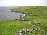 | |||
| Mossbank, Mossbank Bod | 60°27′14″N 1°10′38″W | Category C(S) | 44530 |  | |||
| Swinister, Swinister Old Haa, Including Wall | 60°26′05″N 1°11′06″W | Category B | 44534 | | |||
| Voe, Voe House, Including Garden Wall And Gatepiers | 60°20′58″N 1°16′01″W | Category B | 44536 | | |||
| Brae, Busta House, Including Garden Walls, Steps, Gates And Gatepiers, Boathouse, Harbour And Slipway, And Doocot | 60°23′07″N 1°22′17″W | Category B | 5887 |  | |||
| Voe, Old Olnafirth Kirk, Including Kirkyard Wall, Gatepiers, And Enclosures | 60°21′16″N 1°16′05″W | Category B | 5888 | _20080822_01.jpg) | |||
| Mossbank, Mossbank Lighthouse | 60°27′13″N 1°10′37″W | Category C(S) | 44532 |  | |||
| Mossbank, Mossbank Haa, Including Outbuildings And Wall | 60°27′42″N 1°10′56″W | Category C(S) | 44531 |  | |||
| Brae, Brae House, With Pier And Outbuildings | 60°23′34″N 1°21′07″W | Category B | 5271 | | |||
| Garth, Pony Pund, Including Gates, And Adjoining Outbuildings | 60°27′10″N 1°15′24″W | Category B | 44527 | | |||
| Mossbank, Erlangen Including Garden Wall | 60°27′42″N 1°11′00″W | Category C(S) | 44529 | | |||
| Swinster, Pony Pund | 60°25′53″N 1°11′47″W | Category B | 44533 | |
Key
The scheme for classifying buildings in Scotland is:
- Category A: "buildings of national or international importance, either architectural or historic; or fine, little-altered examples of some particular period, style or building type."[1]
- Category B: "buildings of regional or more than local importance; or major examples of some particular period, style or building type, which may have been altered."[1]
- Category C: "buildings of local importance; lesser examples of any period, style, or building type, as originally constructed or moderately altered; and simple traditional buildings which group well with other listed buildings."[1]
In March 2016 there were 47,288 listed buildings in Scotland. Of these, 8% were Category A, and 50% were Category B, with the remaining 42% being Category C.[2]
Notes
- Sometimes known as OSGB36, the grid reference (where provided) is based on the British national grid reference system used by the Ordnance Survey.
• "Guide to National Grid". Ordnance Survey. Retrieved 12 December 2007.
• "Get-a-map". Ordnance Survey. Retrieved 17 December 2007. - Historic Environment Scotland assign a unique alphanumeric identifier to each designated site in Scotland, for listed buildings this always begins with "LB", for example "LB12345".
gollark: You *should*, the code generates one.
gollark: ???
gollark: ++magic sql select * from user_config
gollark: It keeps not committing your achievements somehow?
gollark: Oopsie.
References
- All entries, addresses and coordinates are based on data from Historic Scotland. This data falls under the Open Government Licence
- "What is Listing?". Historic Environment Scotland. Retrieved 29 May 2018.
- Scotland's Historic Environment Audit 2016 (PDF). Historic Environment Scotland and the Built Environment Forum Scotland. pp. 15–16. Retrieved 29 May 2018.
This article is issued from Wikipedia. The text is licensed under Creative Commons - Attribution - Sharealike. Additional terms may apply for the media files.