List of listed buildings in Arbroath And St Vigeans, Angus
List
| Name | Location | Date Listed | Grid Ref. [note 1] | Geo-coordinates | Notes | LB Number [note 2] | Image |
|---|---|---|---|---|---|---|---|
| Woodside House, South Gatelodge Including Boundary Walls And Gatepiers | 56°34′23″N 2°37′07″W | Category C(S) | 6473 |  | |||
| Nos. 5-8, Auchmithie | 56°35′22″N 2°31′22″W | Category C(S) | 4728 | 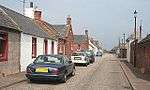 | |||
| 1-6 Fountain Square, Auchmithie | 56°35′23″N 2°31′21″W | Category C(S) | 4733 | 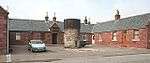 | |||
| Colliston Castle | 56°36′29″N 2°37′58″W | Category B | 4740 | 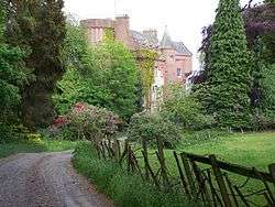 | |||
| Parish Kirk, Manse | 56°34′32″N 2°35′25″W | Category C(S) | 4743 | | |||
| East Kirkton Farmhouse | 56°34′25″N 2°35′47″W | Category B | 4745 | | |||
| Seaton House | 56°34′27″N 2°33′28″W | Category B | 4746 | | |||
| Parkhill Mains Farmhouse | 56°36′09″N 2°34′32″W | Category C(S) | 4758 | | |||
| Windyhills House | 56°34′59″N 2°32′03″W | Category B | 4762 | | |||
| No. 1, Kirkstyle, St. Vigeans | 56°34′37″N 2°35′24″W | Category B | 4774 | 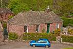 | |||
| Nos. 5-8, Kirkstyle, St. Vigeans | 56°34′37″N 2°35′26″W | Category B | 4776 | 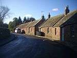 | |||
| Letham House - West Gates And Lodges | 56°34′52″N 2°36′00″W | Category B | 4778 | 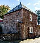 | |||
| St Vigeans Primary School | 56°34′44″N 2°35′17″W | Category B | 48272 | _-_geograph.org.uk_-_1199382.jpg) | |||
| Woodside House Including Sundial To South | 56°34′28″N 2°37′05″W | Category B | 6471 | | |||
| Woodside House, Former Steading And Water Tower | 56°34′30″N 2°37′04″W | Category C(S) | 6472 | | |||
| North Tarry - Garden Walls | 56°34′39″N 2°34′55″W | Category B | 4753 | | |||
| Parkhill House | 56°35′55″N 2°34′47″W | Category B | 4756 | | |||
| Cairnton Farmhouse | 56°36′43″N 2°32′22″W | Category B | 4769 | | |||
| No. 16, Auchmithie | 56°35′24″N 2°31′19″W | Category C(S) | 4729 | .JPG) | |||
| 66 Auchmithie ("Musselcrag" Craft Shop) | 56°35′22″N 2°31′21″W | Category B | 4732 | .JPG) | |||
| Letham Grange - Doocot | 56°36′07″N 2°36′51″W | Category B | 4735 | | |||
| North Tarry House | 56°34′37″N 2°34′56″W | Category B | 4751 | | |||
| "Lyona", Marywell | 56°35′09″N 2°34′16″W | Category C(S) | 4764 | | |||
| Newton House | 56°36′24″N 2°33′32″W | Category B | 4767 | | |||
| Woodville House, Lodge And Gatepiers | 56°34′51″N 2°37′50″W | Category B | 4722 | | |||
| Auchmithie Kirk | 56°35′19″N 2°31′31″W | Category B | 4725 | 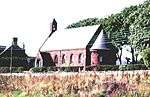 | |||
| Nos. 1-3, Auchmithie | 56°35′21″N 2°31′24″W | Category C(S) | 4727 | 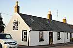 | |||
| Rosely Hotel | 56°34′22″N 2°37′15″W | Category B | 4742 | | |||
| Letham Grange - East Lodge Gates | 56°36′04″N 2°35′59″W | Category C(S) | 4760 | | |||
| Marywell - North-East Side | 56°35′15″N 2°34′13″W | Category C(S) | 4765 | | |||
| Newton House - West Lodge | 56°36′14″N 2°33′35″W | Category B | 4766 | | |||
| St. Vigeans Bridge Over Brothock Burn | 56°34′36″N 2°35′22″W | Category B | 4773 | 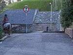 | |||
| Nos. 2-4, Kirkstyle, St. Vigeans | 56°34′37″N 2°35′25″W | Category B | 4775 | 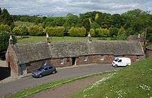 | |||
| Letham Mill Bridge Over Brothock Burn | 56°35′01″N 2°35′50″W | Category C(S) | 108 | 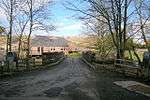 | |||
| Former Stables And Coach House, Seaton House | 56°34′29″N 2°33′29″W | Category B | 5108 | | |||
| Abbeythune - Cottage | 56°37′14″N 2°32′23″W | Category C(S) | 4724 | | |||
| Auchmithie School | 56°35′16″N 2°31′35″W | Category C(S) | 4726 | | |||
| Letham Grange House | 56°36′06″N 2°36′47″W | Category B | 4734 | 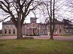 | |||
| West Seaton Farmhouse | 56°33′55″N 2°33′27″W | Category B | 4749 | | |||
| Seaton House Tower | 56°34′27″N 2°33′30″W | Category B | 4752 | | |||
| Letham Grange East Lodge | 56°36′04″N 2°35′59″W | Category C(S) | 4759 | | |||
| Windyhills - Walled Garden | 56°34′59″N 2°32′02″W | Category B | 4763 | | |||
| Letham House | 56°34′52″N 2°35′58″W | Category B | 4777 | 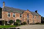 | |||
| Letham House - Walled Garden | 56°34′50″N 2°36′00″W | Category B | 4779 | 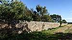 | |||
| 38 Auchmithie | 56°35′23″N 2°31′16″W | Category C(S) | 4730 | | |||
| Captain's House, (Formerly Woodlands), Royal Naval Air Station | 56°35′03″N 2°37′48″W | Category B | 4739 | | |||
| Seaton House - West Lodge | 56°34′27″N 2°34′00″W | Category B | 4747 | | |||
| East Seaton Farmhouse | 56°34′15″N 2°33′07″W | Category C(S) | 4748 | | |||
| Tarry Mill - Out Building | 56°34′49″N 2°35′02″W | Category B | 4754 | | |||
| Kirkyard Walls | 56°34′37″N 2°35′25″W | Category B | 4771 | | |||
| 50 Auchmithie | 56°35′23″N 2°31′17″W | Category C(S) | 4731 | | |||
| Letham Grange - North Entrance Gateway | 56°36′13″N 2°37′19″W | Category C(S) | 4736 | | |||
| North Tarry - South Gates | 56°34′32″N 2°35′00″W | Category C(S) | 4750 |  | |||
| Letham Mill Farmhouse | 56°35′01″N 2°35′45″W | Category C(S) | 4755 | | |||
| Parkhill - Sundial | 56°35′55″N 2°34′48″W | Category C(S) | 4757 | | |||
| Seaton House - Cottage | 56°34′12″N 2°33′15″W | Category C(S) | 4761 | | |||
| Bell Rock Lighthouse | 56°25′58″N 2°23′17″W | Category A | 45197 | | |||
| Abbeythune House | 56°37′08″N 2°32′24″W | Category B | 4723 | | |||
| East Mains Of Colliston Farmhouse | 56°36′12″N 2°37′37″W | Category B | 4737 | | |||
| Colliston Mill Smithy | 56°36′08″N 2°39′00″W | Category C(S) | 4738 | | |||
| Earth-House, Cairn Conan | 56°35′44″N 2°41′48″W | Category B | 4741 | | |||
| Elm Bank | 56°34′32″N 2°35′36″W | Category B | 4744 | | |||
| Old Wheelwright's Workshop, Drunkendub | 56°36′31″N 2°32′58″W | Category C(S) | 4768 | | |||
| St. Vigeans Parish Kirk | 56°34′36″N 2°35′25″W | Category A | 4770 | 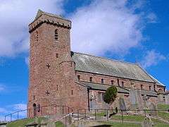 | |||
| Hearse House | 56°34′32″N 2°35′24″W | Category B | 4772 | | |||
| Angus, Arbroath, Rm Condor, Control Tower | 56°34′58″N 2°37′19″W | Category C(S) | 50470 | |
Key
The scheme for classifying buildings in Scotland is:
- Category A: "buildings of national or international importance, either architectural or historic; or fine, little-altered examples of some particular period, style or building type."[1]
- Category B: "buildings of regional or more than local importance; or major examples of some particular period, style or building type, which may have been altered."[1]
- Category C: "buildings of local importance; lesser examples of any period, style, or building type, as originally constructed or moderately altered; and simple traditional buildings which group well with other listed buildings."[1]
In March 2016 there were 47,288 listed buildings in Scotland. Of these, 8% were Category A, and 50% were Category B, with the remaining 42% being Category C.[2]
gollark: You're running a currency on top of krist, or...?
gollark: In any case, other people could probably help somehow.
gollark: OR DOES HE?
gollark: JACK?
gollark: I don't know.
See also
- List of listed buildings in Arbroath, Angus - for listed buildings within the boundaries of Arbroath.
- List of listed buildings in Angus
Notes
- Sometimes known as OSGB36, the grid reference (where provided) is based on the British national grid reference system used by the Ordnance Survey.
• "Guide to National Grid". Ordnance Survey. Retrieved 2007-12-12.
• "Get-a-map". Ordnance Survey. Retrieved 2007-12-17. - Historic Environment Scotland assign a unique alphanumeric identifier to each designated site in Scotland, for listed buildings this always begins with "LB", for example "LB12345".
References
- All entries, addresses and coordinates are based on data from Historic Scotland. This data falls under the Open Government Licence
- "What is Listing?". Historic Environment Scotland. Retrieved 29 May 2018.
- Scotland's Historic Environment Audit 2016 (PDF). Historic Environment Scotland and the Built Environment Forum Scotland. pp. 15–16. Retrieved 29 May 2018.
This article is issued from Wikipedia. The text is licensed under Creative Commons - Attribution - Sharealike. Additional terms may apply for the media files.