List of listed buildings in Arbroath, Angus
List
| Name | Location | Date Listed | Grid Ref. [note 1] | Geo-coordinates | Notes | LB Number [note 2] | Image |
|---|---|---|---|---|---|---|---|
| Nos. 23, 25 And 27, Marketgate | 56°33′26″N 2°34′57″W | Category B | 21203 |  | |||
| Nos. 48 And 50, Marketgate | 56°33′27″N 2°35′00″W | Category C(S) | 21211 | | |||
| No. 56, Marketgate | 56°33′27″N 2°35′00″W | Category C(S) | 21213 | | |||
| No. 64, Marketgate | 56°33′28″N 2°35′00″W | Category B | 21214 | | |||
| Nos. 9 And 11, Old Shore Head | 56°33′23″N 2°34′51″W | Category C(S) | 21217 | | |||
| Nos. 6-9, The Shore | 56°33′23″N 2°35′05″W | Category B | 21227 | 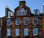 | |||
| No. 37, Millgate | 56°33′29″N 2°35′13″W | Category C(S) | 21233 | | |||
| Nos. 12-18, Keptie Street | 56°33′30″N 2°35′20″W | Category B | 21234 | | |||
| St Thomas Of Canterbury Roman Catholic Church, Dishlandtown Street | 56°33′22″N 2°35′26″W | Category B | 21241 | 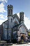 | |||
| Gladshiel Private Hotel, Ogilvy Place | 56°33′52″N 2°35′26″W | Category C(S) | 21246 | | |||
| Hospital Field - Doocot | 56°33′21″N 2°36′52″W | Category B | 21257 | | |||
| Arbroath Abbey - Conventual Building | 56°33′44″N 2°34′58″W | Category A | 21131 | | |||
| Arbroath Abbey - Regality Tower | 56°33′44″N 2°35′02″W | Category A | 21133 | 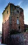 | |||
| West Abbey Street, Abbey Parish Church Including Boundary Walls, Gatepiers And Church Halls | 56°33′41″N 2°34′54″W | Category B | 21136 | 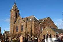 | |||
| Nos. 267, 269 And 271 High Street | 56°33′42″N 2°35′00″W | Category C(S) | 21138 | | |||
| Inverbrothock Parish Church, James Street | 56°33′43″N 2°35′08″W | Category B | 21139 |  | |||
| No. 3, Ponderlaw Street | 56°33′37″N 2°34′46″W | Category C(S) | 21149 | | |||
| Nos. 36 And 38, Hill Street | 56°33′31″N 2°34′47″W | Category C(S) | 21153 | | |||
| Nos. 115 And 117, High Street, National Commercial Bank | 56°33′32″N 2°34′53″W | Category C(S) | 21160 |  | |||
| Nos. 147 And 149, High Street | 56°33′34″N 2°34′53″W | Category C(S) | 21165 | | |||
| Nos. 80-84 High Street | 56°33′31″N 2°34′54″W | Category B | 21170 | | |||
| Nos. 90, 92 And 94, High Street, Guildry Buildings | 56°33′32″N 2°34′55″W | Category C(S) | 21173 |  | |||
| 124, High Street | 56°33′34″N 2°34′55″W | Category C(S) | 21180 | | |||
| Seaton Smithy | 56°34′20″N 2°34′06″W | Category C(S) | 47321 | | |||
| No. 17, Marketgate | 56°33′24″N 2°34′56″W | Category B | 21201 | | |||
| No. 7, Old Shore Head | 56°33′24″N 2°34′50″W | Category C(S) | 21216 | | |||
| Mortuary Chapel - Western Cemetery | 56°33′59″N 2°36′44″W | Category A | 21252 |  | |||
| Arbroath Abbey - Abbot's House | 56°33′43″N 2°34′58″W | Category A | 21134 | | |||
| Abbey Lodge, Abbey Street | 56°33′43″N 2°35′01″W | Category B | 21137 | | |||
| Nos. 123 And 125, High Street | 56°33′32″N 2°34′53″W | Category C(S) | 21162 | | |||
| Nos. 129 - 133 & 141 High Street, Royal Hotel | 56°33′33″N 2°34′53″W | Category B | 21163 | | |||
| Nos. 163 And 165, High Street, Formerly The White Hart Inn | 56°33′35″N 2°34′53″W | Category B | 21167 | | |||
| High Street, At Corner Of Commerce Street, Bank Of Scotland | 56°33′30″N 2°34′54″W | Category B | 21168 |  | |||
| No. 10, Marketgate | 56°33′23″N 2°34′57″W | Category B | 21190 | | |||
| No. 16, Marketgate | 56°33′24″N 2°34′57″W | Category B | 21193 | | |||
| No. 21, Marketgate "The Ship Inn" | 56°33′25″N 2°34′57″W | Category C(S) | 21202 |  | |||
| Ladyloan, Bell Rock Lighthouse Signal Tower And Entrance Lodges | 56°33′17″N 2°35′11″W | Category A | 21230 |  | |||
| Nos. 7 And 9, West Keptie Street | 56°33′34″N 2°35′35″W | Category B | 21236 |  | |||
| 3 Albert Street, Mound House | 56°33′21″N 2°35′33″W | Category C(S) | 21242 |  | |||
| "Collingdale" (Formerly Cairniehill Stables) | 56°33′56″N 2°35′43″W | Category C(S) | 21249 | | |||
| Kirk Square, K6 Telephone Kiosk | 56°33′36″N 2°34′52″W | Category B | 21258 | 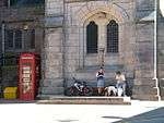 | |||
| Arbroath Abbey - Abbey Church And Precincts | 56°33′45″N 2°34′56″W | Category A | 21130 | 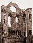 | |||
| Arbroath Abbey - Pend | 56°33′44″N 2°35′01″W | Category A | 21132 | | |||
| Dens Road, Baltic Works (Former Arbroath Warehouse Limited Bond Number 1) | 56°33′50″N 2°35′18″W | Category A | 21141 | 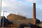 | |||
| Wesley House, Ponderlaw Street | 56°33′37″N 2°34′43″W | Category C(S) | 21148 | | |||
| 100 And 102 High Street | 56°33′32″N 2°34′55″W | Category C(S) | 21175 | | |||
| "Ye Lorne Bar", Commerce Street | 56°33′30″N 2°34′56″W | Category C(S) | 21185 |  | |||
| Halls Of Arbroath Old Church, Commerce Street | 56°33′29″N 2°34′55″W | Category C(S) | 21186 |  | |||
| Bank Of Scotland Brothock Bridge | 56°33′30″N 2°34′59″W | Category B | 21187 | | |||
| No. 14, Marketgate | 56°33′23″N 2°34′57″W | Category B | 21192 | | |||
| Ladybridge House, Ladybridge Street | 56°33′24″N 2°34′59″W | Category C(S) | 21196 |  | |||
| No. 15, Marketgate | 56°33′24″N 2°34′56″W | Category B | 21200 | | |||
| 64 High Street, Webster Memorial Theatre | 56°33′29″N 2°34′53″W | Category C(S) | 51409 |  | |||
| No. 33, Marketgate | 56°33′27″N 2°34′58″W | Category C(S) | 21206 | | |||
| No. 2 And 3, The Shore | 56°33′23″N 2°35′03″W | Category B | 21225 |  | |||
| Ladyloan School Ladyloan | 56°33′11″N 2°35′24″W | Category B | 21232 |  | |||
| Keptie Road, Arbroath High School | 56°33′32″N 2°35′42″W | Category B | 21239 |  | |||
| Water Tower, Keptie Hill | 56°33′27″N 2°35′41″W | Category B | 21240 |  | |||
| Hospital Field | 56°33′16″N 2°36′37″W | Category A | 21253 | 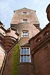 | |||
| Hospital Field - Fernery | 56°33′16″N 2°36′34″W | Category B | 21254 | 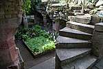 | |||
| Hospital Field - North Lodge | 56°33′29″N 2°36′48″W | Category B | 21255 | | |||
| St Mary's Rectory, Springfield Terrace | 56°33′40″N 2°34′33″W | Category C(S) | 21146 | | |||
| No. 37, West Newgate Street, Newgate House | 56°33′30″N 2°34′42″W | Category B | 21152 | | |||
| No. 42, Hill Street | 56°33′31″N 2°34′45″W | Category B | 21155 | | |||
| Nos. 99 And 101, High Street | 56°33′31″N 2°34′53″W | Category C(S) | 21158 | | |||
| No. 145 High Street | 56°33′34″N 2°34′52″W | Category C(S) | 21164 | | |||
| 78 High Street And 3 And 5 Commerce Street, Court House | 56°33′30″N 2°34′55″W | Category B | 21169 | 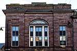 | |||
| 114 And 116, High Street | 56°33′33″N 2°34′55″W | Category C(S) | 21178 | | |||
| 118 And 122 High Street | 56°33′34″N 2°34′54″W | Category C(S) | 21179 | | |||
| Arbroath Guide Offices, Market Place | 56°33′32″N 2°34′56″W | Category C(S) | 21183 | 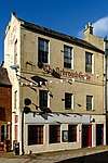 | |||
| No. 8, Marketgate | 56°33′23″N 2°34′56″W | Category B | 21189 | | |||
| Nos. 52 And 54, Marketgate | 56°33′27″N 2°35′00″W | Category C(S) | 21212 | | |||
| No. 13, Old Shore Head, "The Commercial Inn" | 56°33′23″N 2°34′52″W | Category C(S) | 21218 | 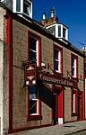 | |||
| No. 7, High Street | 56°33′24″N 2°34′47″W | Category C(S) | 21222 | | |||
| No. 1, The Shore | 56°33′24″N 2°35′03″W | Category B | 21224 | .jpg) | |||
| No. 13, The Shore | 56°33′23″N 2°35′06″W | Category B | 21229 | 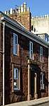 | |||
| 4 And 5 Gayfield | 56°33′12″N 2°35′30″W | Category B | 21245 | | |||
| Arbroath Abbey - Monument In Burial Ground | 56°33′47″N 2°34′56″W | Category B | 21135 | 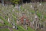 | |||
| Maulesbank House, Maule Street | 56°33′40″N 2°35′07″W | Category B | 21144 | | |||
| Nos. 105, 107 And 109, High Street | 56°33′31″N 2°34′53″W | Category C(S) | 21159 | | |||
| Nos. 151 And 153, High Street | 56°33′34″N 2°34′53″W | Category C(S) | 21166 | | |||
| 104-108 High Street | 56°33′33″N 2°34′55″W | Category C(S) | 21176 | | |||
| No. 20, Marketgate | 56°33′24″N 2°34′58″W | Category B | 21195 | 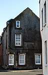 | |||
| No. 44, Marketgate | 56°33′26″N 2°35′00″W | Category B | 21209 | | |||
| Nos. 17 And 19, High Street | 56°33′25″N 2°34′48″W | Category C(S) | 21223 | | |||
| No. 4, The Shore, Harbour House | 56°33′23″N 2°35′04″W | Category B | 21226 | .jpg) | |||
| "The Croft" No. 31, Keptie Road | 56°33′34″N 2°36′01″W | Category C(S) | 21238 | .jpg) | |||
| Infirmary Grounds, House At North-West Corner | 56°33′17″N 2°35′54″W | Category C(S) | 21243 |  | |||
| Millgate, Windmill Hotel | 56°33′15″N 2°35′29″W | Category C(S) | 21244 |  | |||
| Inverbrothock Public School | 56°33′55″N 2°35′33″W | Category C(S) | 21247 |  | |||
| No. 6 Marketgate | 56°33′23″N 2°34′56″W | Category B | 21188 |  | |||
| No. 12, Marketgate | 56°33′23″N 2°34′57″W | Category B | 21191 | | |||
| No. 18, Marketgate | 56°33′24″N 2°34′58″W | Category B | 21194 | | |||
| No. 11, Marketgate | 56°33′24″N 2°34′56″W | Category B | 21198 | | |||
| No. 29, Marketgate | 56°33′26″N 2°34′57″W | Category B | 21204 | | |||
| Nos. 39, 41 And 43, Marketgate | 56°33′27″N 2°34′58″W | Category C(S) | 21207 |  | |||
| No. 46, Marketgate | 56°33′26″N 2°35′00″W | Category B | 21210 | | |||
| No. 23, Old Shore Head | 56°33′23″N 2°34′54″W | Category B | 21220 | | |||
| Nos. 3 And 5, High Street | 56°33′23″N 2°34′47″W | Category B | 21221 |  | |||
| The Elms | 56°33′59″N 2°36′01″W | Category A | 21250 | .jpg) | |||
| House In Hays Lane | 56°33′51″N 2°34′55″W | Category C(S) | 21140 | | |||
| Gravesend, Burnside Works | 56°33′33″N 2°35′03″W | Category B | 21143 | | |||
| St Mary's Episcopal Church, Springfield Terrace | 56°33′41″N 2°34′33″W | Category B | 21145 |  | |||
| Public Library And Art Gallery, Hill Place | 56°33′36″N 2°34′46″W | Category B | 21150 |  | |||
| Old Church Of Arbroath, Kirk Square | 56°33′36″N 2°34′51″W | Category B | 21151 |  | |||
| No. 93, High Street | 56°33′31″N 2°34′52″W | Category C(S) | 21157 | | |||
| Nos. 121 And 123, High Street | 56°33′32″N 2°34′52″W | Category C(S) | 21161 | | |||
| 96 And 98, High Street | 56°33′32″N 2°34′55″W | Category C(S) | 21174 | | |||
| 110 And 112, High Street | 56°33′33″N 2°34′55″W | Category C(S) | 21177 | | |||
| Howard Street Knox's Church Including Boundary Walls And Railings | 56°33′47″N 2°35′29″W | Category B | 21181 | 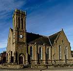 | |||
| No. 9, Marketgate | 56°33′23″N 2°34′55″W | Category B | 21197 | | |||
| No. 31, Marketgate, "Kingsley House" | 56°33′26″N 2°34′57″W | Category B | 21205 | | |||
| No. 42, Marketgate | 56°33′26″N 2°35′00″W | Category B | 21208 | | |||
| No. 5, Old Shore Head | 56°33′24″N 2°34′50″W | Category C(S) | 21215 | | |||
| No. 21, Old Shore Head | 56°33′23″N 2°34′54″W | Category B | 21219 | | |||
| Nos. 10 And 11 The Shore | 56°33′23″N 2°35′05″W | Category B | 21228 | | |||
| Jock's Lodge, Gowan Street | 56°33′29″N 2°35′30″W | Category B | 21235 | | |||
| St Margaret's Church, Keptie Road | 56°33′36″N 2°35′38″W | Category B | 21237 | 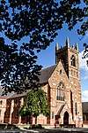 | |||
| The Elms - East Lodge | 56°33′55″N 2°35′57″W | Category B | 21251 | | |||
| Hospital Field - Farmbuilding | 56°33′24″N 2°36′51″W | Category B | 21256 | | |||
| St. John's Methodist Church, 15 Ponderlaw Street | 56°33′37″N 2°34′43″W | Category B | 21147 | 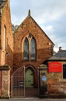 | |||
| No. 40, Hill Street | 56°33′31″N 2°34′46″W | Category C(S) | 21154 | | |||
| High Street At Corner Of Hill Street, Clydesdale And North Bank And Prudential Buildings | 56°33′31″N 2°34′52″W | Category B | 21156 |  | |||
| No. 86 High Street | 56°33′31″N 2°34′55″W | Category C(S) | 21171 | | |||
| No. 88, High Street Town House | 56°33′31″N 2°34′55″W | Category B | 21172 |  | |||
| Old Corn Exchange, Market Place | 56°33′31″N 2°34′57″W | Category B | 21182 |  | |||
| 2 And 8 Market Place | 56°33′31″N 2°34′55″W | Category C(S) | 21184 | | |||
| No. 13, Marketgate | 56°33′24″N 2°34′56″W | Category B | 21199 | | |||
| Hill Road, Grant's Former Boot/Shoe Factory | 56°33′30″N 2°34′34″W | Category B | 48019 |  |
Key
The scheme for classifying buildings in Scotland is:
- Category A: "buildings of national or international importance, either architectural or historic; or fine, little-altered examples of some particular period, style or building type."[1]
- Category B: "buildings of regional or more than local importance; or major examples of some particular period, style or building type, which may have been altered."[1]
- Category C: "buildings of local importance; lesser examples of any period, style, or building type, as originally constructed or moderately altered; and simple traditional buildings which group well with other listed buildings."[1]
In March 2016 there were 47,288 listed buildings in Scotland. Of these, 8% were Category A, and 50% were Category B, with the remaining 42% being Category C.[2]
gollark: Unlike other languages which are annoying and inconsistent, or lack useful features for no reason.
gollark: I like Lua. It's simple, flexible and powerful.
gollark: Sure it is. Some programs use different argument formats.
gollark: It is, yes; I like the CraftOS shell quite a lot.
gollark: That doesn't really seem better. I guess I could add a command to search for programs fuzzily.
See also
Notes
- Sometimes known as OSGB36, the grid reference (where provided) is based on the British national grid reference system used by the Ordnance Survey.
• "Guide to National Grid". Ordnance Survey. Retrieved 12 December 2007.
• "Get-a-map". Ordnance Survey. Retrieved 17 December 2007. - Historic Environment Scotland assign a unique alphanumeric identifier to each designated site in Scotland, for listed buildings this always begins with "LB", for example "LB12345".
References
- All entries, addresses and coordinates are based on data from Historic Scotland. This data falls under the Open Government Licence
- "What is Listing?". Historic Environment Scotland. Retrieved 29 May 2018.
- Scotland's Historic Environment Audit 2016 (PDF). Historic Environment Scotland and the Built Environment Forum Scotland. pp. 15–16. Retrieved 29 May 2018.
This article is issued from Wikipedia. The text is licensed under Creative Commons - Attribution - Sharealike. Additional terms may apply for the media files.